| WPC Met Watch |
|
|
Mesoscale Precipitation Discussion: #0239 |
|
(Issued at 243 AM EDT Wed May 07 2025
) |
|
| MPD Selection |
|
|
|
|
|

Mesoscale Precipitation Discussion 0239
NWS Weather Prediction Center College Park MD
243 AM EDT Wed May 07 2025

Areas affected...Central Gulf Coast...

Concerning...Heavy rainfall...Flash flooding likely

Valid 070700Z - 071300Z

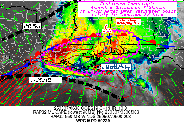
SUMMARY...Mature MCS starting to weaken with reduced inflow, but
embedded intense rates of 2"/hr will continue to over-run frontal
zone and repeat over saturating soils along I-10 maintaining
likely rapid inundation flooding concerns through daybreak.

DISCUSSION...GOES-E WV suite shows very large, anomalous closed
low over the Southern Plains with large mature MCS well displaced
at the far eastward extent of its influence.  Given the broadening
of the larger cyclone, the mid to upper-level forcing is
diminishing as the jet slowly reduces in speed and responding
winds in the lower levels continue to weaken in turn.  While they
are weakening, the strength and orientation remain sufficient to
maintain the complex throughout the remainder of the overnight
period with ideal split in dual jet structure with 100 kt jet
lifting northeast across NE TX into TN, while the subtropical jet
(60-70kt) ridges ideally, bending southeastward across the western
to central Gulf providing excellent divergence/evacuation for to
maintain the MCS.

The MCS's MCV is over eastern-MS but is slowly shearing along the
SW to NE flow and low level winds are veering across the central
Gulf, reducing orthogonality of LLJ to the leading squall line
across S MS into far SE LA.  Source of greatest instability and
enhanced moisture also resides upstream into the northwest Gulf,
so the fast moving, but intense rain-rates will further reduce
overall totals crossing into S AL/W FL though scattered incidents
of sub-hourly 1.5-2" remain possible and urban flooding concerns
remain.

The greater concern remains upstream across western LA into
central LA, where outflow from aforementioned bow is starting to
lay flat west to east southeast LA, and perhaps align with the
slowly sagging cold front.  Currently, surface to boundary layer
flow remains orthogonal to the boundary-combining front; but 850mb
flow is already veering less orthogonal out of the SW to WSW.  The
jet is also expected to reduce in magnitude from 30kts toward
15kts by 10z, reducing upglide ascent.  Given the Gulf remains
very warm, MLCAPEs of 2000-3000 J/kg will remain with deep moist
profile support 2-2.25" total PWats.  So while flux may reduce,
the unstable environment will support scattered development from
SW LA across south-central LA with capability of 2"/hr rates.
Cells will once again cross saturated/flooded areas and maintain
ongoing flooding conditions through morning, with slow improvement
as scattered cells further reduce to isolated.  Still pockets of
additional 3-4" totals are probable through 12z and so flooding
remains likely especially along of I-10 in LA.

Note: Low level flow environment is going to slack for a time
toward the end of the valid time; however, there is an upstream
shortwave that will trail the right entrance of the exiting
upper-level jet streak AoA 12z and appears to be triggering
convection west of the Lower Rio Grande Valley currently; this
will slide eastward and increase lower level flow/convergence
again with another shot of thunderstorms.  Will continue to
monitor those trends closely.

Gallina

ATTN...WFO...JAN...LCH...LIX...MOB...TAE...

ATTN...RFC...LMRFC...SERFC...WGRFC...NWC...

LAT...LON   31948811 31928756 31708670 30978638 30348665
            30038832 29588882 28978910 28938994 28999089
            29179129 29399197 29629301 29699363 30019361
            30419304 30899189 31349021 31828881
Download in GIS format: Shapefile
| KML
Last Updated: 243 AM EDT Wed May 07 2025
|


