| WPC Met Watch |
|
|
Mesoscale Precipitation Discussion: #0240 |
|
(Issued at 719 AM EDT Wed May 07 2025
) |
|
| MPD Selection |
|
|
|
|
|

Mesoscale Precipitation Discussion 0240
NWS Weather Prediction Center College Park MD
719 AM EDT Wed May 07 2025

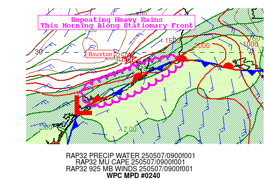
Areas affected...Middle to Upper Texas Coasts

Concerning...Heavy rainfall...Flash flooding possible

Valid 071118Z - 071505Z

SUMMARY...Repeating heavy rain along stationary front over Middle
to Upper Texas Coasts this morning. Embedded intense rates of
2"/hr will continue over the next few hours with localized
additional rain >4" and flash flooding possible immediately inland
from the coast, but south of Houston proper.

DISCUSSION...Ample Gulf moisture has surged back over the coast
along a stationary front stretching from Matagorda Bay to the
coastal border with Louisiana. Deep layer SWly flow around an
centered over western OK is parallel to a stationary front along
the coast which is limiting previous progression into the Gulf.
This analysis is not seen in recent RAP runs which depict the
front having pushed into the Gulf. So the 2" PW axis remains along
the coast where the heavy rain is occurring. This moisture,
combined with 2000 J/kg MUCAPE has allowed a line of heavy
thunderstorms to develop.

The SWly flow will allow motion in the orientation of the activity
as fresh air moves in from the Gulf allowing redevelopment. KHGX
has 1hr rainfall estimates of 1.5-2"/hr near Matagorda Bay to
southern Brazoria County. Redevelopment ahead of a multi cell
cluster just north of Matagorda Bay at 11Z, associated with a
surface low, will continue allowing repeating heavy activity and
the potential for 4" locally through about 14Z. This area has high
FFG, so any flash flooding should be limited to urbanized areas.
Since the front is quite strong, expect the heaviest activity to
remain south of Houston proper, but should a concern for the
Galveston area until the surface wave passes, shunting activity
into the Gulf.


Jackson

ATTN...WFO...CRP...HGX...LCH...

ATTN...RFC...LMRFC...WGRFC...NWC...

LAT...LON   29829384 29679382 28949496 28489622 28909658
            29399543 29699465
Download in GIS format: Shapefile
| KML
Last Updated: 719 AM EDT Wed May 07 2025
|


