| WPC Met Watch |
|
|
Mesoscale Precipitation Discussion: #0241 |
|
(Issued at 853 AM EDT Wed May 07 2025
) |
|
| MPD Selection |
|
|
|
|
|

Mesoscale Precipitation Discussion 0241
NWS Weather Prediction Center College Park MD
853 AM EDT Wed May 07 2025

Areas affected...Southern Louisiana

Concerning...Heavy rainfall...Flash flooding possible

Valid 071250Z - 071805Z

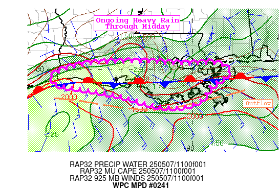
SUMMARY...Continued repeating heavy rain through midday for far
southern Louisiana. The focus is pushing into the Gulf, so the
flash flood threat is considered possible, including for New
Orleans.

DISCUSSION...A stationary front remains over southern Louisiana,
though outflow is noted from regional radar as pushing into the
Gulf. There remains a heavy rain focus along the frontal boundary
south of I-10 with rainfall rates around 1.5"/hr from KLCH and
KHDC. This is despite IR GOES imagery depicting warming cloud tops
over the past couple of hours.
There is quite a PW gradient over southern LA with values of 1.75
to 1.9" south of I-10 with an east-west gradient to instability
with more over southwest LA (1500-2000 J/kg) vs southeast (around
1000 J/kg). Deep layer SWly flow around 25kt with upwind
propagation to the east will keep activity moving along the
frontal boundary to in or near New Orleans over the next few hours.
Southwest LA has been spared from the heavy rain of the past day,
so this activity is moving into less susceptible areas (though
NOLA is perpetually susceptible). The main flash flood threat
through midday is for urbanized areas.


Jackson

ATTN...WFO...LCH...LIX...

ATTN...RFC...LMRFC...WGRFC...NWC...

LAT...LON   30199118 30139021 30168943 29938900 29528952
            29098988 28979079 29319211 29519320 29599375
            29809393 30029345 30169261
Download in GIS format: Shapefile
| KML
Last Updated: 853 AM EDT Wed May 07 2025
|


