| WPC Met Watch |
|
|
Mesoscale Precipitation Discussion: #0256 |
|
(Issued at 930 PM EDT Sun May 11 2025
) |
|
| MPD Selection |
|
|
|
|
|

Mesoscale Precipitation Discussion 0256
NWS Weather Prediction Center College Park MD
930 PM EDT Sun May 11 2025

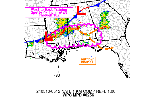
Areas affected...Northwest to Central MS...Central and Southern AL

Concerning...Heavy rainfall...Flash flooding possible

Valid 120130Z - 120730Z

SUMMARY...Bands of showers and thunderstorms will continue into
the overnight hours across areas of northwest to central MS along
with adjacent areas of central and southern AL. Concerns for
cell-training with heavy rainfall rates will pose a threat for
scattered areas of flash flooding.

DISCUSSION...The early evening GOES-E IR satellite imagery shows
an elongated southeast/northwest axis of relatively cold-topped
convection continuing to impact areas of central and southern AL
up across central to northwest MS. The bands of convection which
are linear in nature remain concentrated rather close to a frontal
occlusion and are persisting within a moist and moderately
unstable airmass with the aid of divergent flow aloft around the
northeast flank of the deep layer trough/closed low over the lower
MS Valley.

MLCAPE values remain locally on the order of 1000 to 1500 J/kg
with PWs of near 1.5 inches, and this coupled with some modest
shear parameters has been supporting rainfall rates of 1 to 2
inches/hour with the stronger convective cores.

There is a fair amount moisture convergence noted near the
aforementioned frontal occlusion, and this coupled with the
orientation of the convection with the deeper layer cyclonic flow
should continue to yield linear convective structures that will be
conducive for cell-training.

The latest hires model guidance led by the HRRR and the RRFS
collectively support as much as an additional 2 to 4 inches of
rain going through 06Z (1AM CDT). The additional rains are
expected to largely fall on areas that have seen recent rainfall,
and thus with moist/wet antecedent conditions in place, there will
continue to be a concern for scattered areas of flash flooding
going into the overnight hours.

Orrison

ATTN...WFO...BMX...JAN...MEG...MOB...

ATTN...RFC...LMRFC...SERFC...NWC...

LAT...LON   35148972 33888795 33428640 32868585 31808589
            31348657 31368781 31568850 31848912 32498973
            33519061 34799086
Download in GIS format: Shapefile
| KML
Last Updated: 930 PM EDT Sun May 11 2025
|


