| WPC Met Watch |
|
|
Mesoscale Precipitation Discussion: #0267 |
|
(Issued at 1110 PM EDT Tue May 13 2025
) |
|
| MPD Selection |
|
|
|
|
|

Mesoscale Precipitation Discussion 0267
NWS Weather Prediction Center College Park MD
1110 PM EDT Tue May 13 2025

Areas affected...Blue Ridge Mountains across much of VA and into
MD/WV/PA, east into portions of the DMV

Concerning...Heavy rainfall...Flash flooding likely

Valid 140300Z - 140800Z

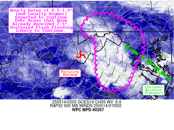
Summary...Rainfall rates of 0.5-1.0" (and locally higher) are
expected to continue over areas that have already received 2-5".
Scattered instances of flash flooding are likely to continue (with
locally significant to catastrophic impacts possible across
portions of the Blue Ridge Mountains).

Discussion...Areas of stratiform rainfall with 0.5-1.0"/hr rates
continue across much of VA and into adjacent portions of MD/WV/PA,
generally along and to the east of the Blue Ridge Mountains.
Embedded convective elements occasionally produce hourly rates in
excess of 1" (per MRMS) estimates, and this is problematically
occurring over areas that have already received 2-5" rainfall
totals over the past 12-24 hours (with some localities in the
vicinity of Shenandoah National Park receiving the bulk of that
amount over the past 3-6 hours, with multiple Flash Flood
Emergencies currently in effect). Deep cyclonic flow with a
northwestward translating mid-level vorticity max and accompanying
diffluence aloft looks to maintain synoptic scale lift and
upper-level support, while moderate to strong low-level moisture
transport (most prominent at 925 mb with 30-40 kt flow) via the
persistent warm conveyor belt directed SE-ESE across the DMV
maintains lower-level support/convergence. While instability is
beginning to wane over much of the region (-200 to -800 J/kg of
MUCAPE over the past 3 hours), buoyancy remains sufficient (MUCAPE
of 100-500 J/kg) to sustain embedded convective elements (in
addition to terrain forcing along the Blue Ridge itself).

Given the aforementioned wet antecedent conditions (with Flash
Flood Guidance over 3-6 hours generally ranging from 1.0-2.0", and
locally even below 1.0") and the expected continued rainfall rates
of 0.5-1.0" (and locally higher) over the next several hours,
scattered instances of flash flooding are likely to continue (and
may be locally significant to catastrophic).

Churchill

ATTN...WFO...AKQ...CTP...LWX...PBZ...RNK...

ATTN...RFC...MARFC...OHRFC...NWC...

LAT...LON   40417842 40337806 40177774 40047742 39957731
            39827714 39677699 39417689 39037691 38777699
            38337724 37577752 37397815 37647857 38047870
            38597871 39387876 39557892 39707931 40027923
            40337893
Download in GIS format: Shapefile
| KML
Last Updated: 1116 PM EDT Tue May 13 2025
|


