| WPC Met Watch |
|
|
Mesoscale Precipitation Discussion: #0271 |
|
(Issued at 549 PM EDT Wed May 14 2025
) |
|
| MPD Selection |
|
|
|
|
|

Mesoscale Precipitation Discussion 0271
NWS Weather Prediction Center College Park MD
549 PM EDT Wed May 14 2025

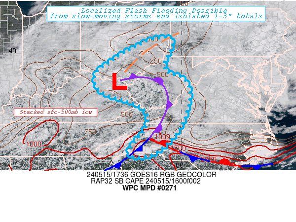
Areas affected...Northern Virginia...

Concerning...Heavy rainfall...Flash flooding likely

Valid 142200Z - 150300Z

SUMMARY...Intense thunderstorms capable of 1.5-1.75"/hr
rates/totals within slow/chaotic cell motions regime resulting in
mergers/collisions and localized 2+" totals in vicinity of
saturated ground conditions likely to induce focused/localized
incidents of flash flooding through early overnight period.

DISCUSSION...GOES-E Visible/EIR and regional RADAR mosaic show
convective evolution is a bit faster than Hi-Res CAM solutions
suggest in timing.  Overall, recent HRRR solutions continue to be
consistent with other 12/18z Hi-Res CAMs with evolution of
convective activity/coverage across northern Virginia; however,
typical to slower timing bias appears to be unfolding at this time.

Strong vorticity center at southeastward end of
elongating/shearing upper-level trough from the Great Lakes/Upper
Ohio Valley is being reinforced by convective activity feeding
back into the circulation across south-central VA.  A slow
north/northeastward lifting of the wave is supporting weak
cyclogenesis across central VA, as well as strengthening
northeasterly flow out of the relatively stable air out of
Maryland, further reinforcing FGEN from the surface wave near KCHO
across the western Northern Neck into the Middle Neck before
angling northward across the Delmarva. As a result, there is a
strong stability gradient along the Potomac River, making
potential for heavy rainfall reduced north of it.  Weak but
sufficient low level/boundary layer southeasterly flow is
providing solid moisture of 1.5"+ north of the vorticity center
into NoVA.  A few hours of solid clearing skies have resulted in
temps rising into the mid to upper 70s, resulting in increasing
SBCAPEs over 1000 J/kg toward 2000 J/kg near the tidal Potomac
River.

With the vorticity center strengthening, DPVA and modest expansion
of divergence aloft into strengthening entrance to 30-40kt 3H jet
streak over PA will continue to support upper-level evacuation for
developing convective cells/clusters. Additionally, steering flow
through 500mb will support northwest then westward motion of cells
across NoVA and with storm influences, may result in slow, chaotic
motions allowing for increased residency for any given cell.
While wind speeds will be relatively weak at 5-10kts for inflow,
directional convergence will aid in raising rainfall
efficiency/potential with 1.5-1.75"/hr rates possible.  Given slow
motions and narrow up/downdrafts, intense cores of 2"+ totals
remain possible, especially later this evening as cells interact
with increased terrain across the Blue Ridge.

Recent significant rainfall further west toward the terrain, has
sizably reduced FFG values that even 3hr FFG values are less than
1" increasing the potential for near zero infiltration supporting
high runoff and likely flash flooding incidents.  Further east
toward I-95, grounds are also have deeper wetness, with ratios in
the 60-75%, but may have more capacity that all but the highest
totals/intense rates over 1.5" may result in flash flooding.  As
such, incidents of flash flooding are considered likely, but
coverage is likely to be wide spread and locally focused.

Gallina

ATTN...WFO...AKQ...LWX...

ATTN...RFC...MARFC...NWC...

LAT...LON   39577796 38977729 38777706 38217655 38007636
            37487651 37267713 37727817 38357918 39167886
            39567842
Download in GIS format: Shapefile
| KML
Last Updated: 549 PM EDT Wed May 14 2025
|


