| WPC Met Watch |
|
|
Mesoscale Precipitation Discussion: #0297 (2019) |
|
(Issued at 425 AM EDT Sun May 26 2019
) |
|
| MPD Selection |
|
|
|
|
|

Mesoscale Precipitation Discussion 0297
NWS Weather Prediction Center College Park MD
425 AM EDT Sun May 26 2019

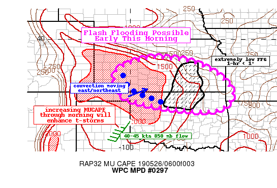
Areas affected...Kansas...Northern Oklahoma

Concerning...Heavy rainfall...Flash flooding possible

Valid 260825Z - 261425Z

Summary...Thunderstorms redeveloping with a surge in elevated
instability will likely lead to more widespread convection early
this morning and potentially some flash flooding over already
saturated soils.

Discussion...As of 08z, GOES-16 IR imagery showed convective
clusters redeveloping over the Oklahoma panhandle and southwest
Kansas per recent cooling cloud tops. KDDC radar imagery shows
more convection developing as well with precip rates starting to
increase up to and slightly over 1".

This activity is forming on the gradient of the elevated
instability, which is surging back into the outlook area. Time
trend analysis shows MUCAPE has increased from 500 to 1500 J/kg in
the area over the last several hours, and the latest RAP forecasts
indicates this trend to continue for a few more hours. With 40 to
45 kts of 850 mb moisture convergence bringing around 1.2 to 1.5"
PWs, storms will be capable of producing moderate to locally heavy
rainfall. Storms will likely move to the east/northeast as the
nose of the instability gradient lifts north/east as well.
Initially hi-res guidance was handling this activity poorly but
the last few runs of the HRRR is beginning to match reality, and
the consensus of the models paint between 1-2" across
south-central Kansas into portions of southeast Kansas through
about 15z. Some localized higher amounts up to 3" will be possible.

While storms will likely be a bit more progressive and likely not
train over any specific location for very long, it will fall on
extremely saturated soils where the recent flash flood guidance is
extremely low (1-hr values less than 0.5" in south-central KS). As
such, while confidence in the evolution of these convective
clusters is slightly below normal, the antecedent conditions alone
suggest flash flooding will be possible even with scattered
thunderstorms around.

Taylor

ATTN...WFO...AMA...DDC...ICT...OUN...SGF...TOP...TSA...

ATTN...RFC...ABRFC...MBRFC...

LAT...LON   38939847 38709660 38179541 37709475 37289439
            36869424 36159474 35989596 36119753 36179802
            36419922 36580000 36890049 37290064 38070086
            38580005 38899897
Last Updated: 425 AM EDT Sun May 26 2019
|


