| WPC Met Watch |
|
|
Mesoscale Precipitation Discussion: #0304 |
|
(Issued at 905 PM EDT Thu May 22 2025
) |
|
| MPD Selection |
|
|
|
|
|

Mesoscale Precipitation Discussion 0304
NWS Weather Prediction Center College Park MD
905 PM EDT Thu May 22 2025

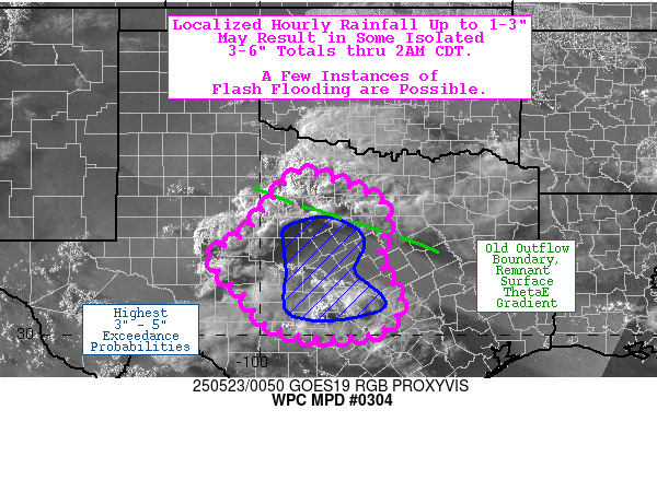
Areas affected...TX Big Country into Hill Country

Concerning...Heavy rainfall...Flash flooding possible

Valid 230105Z - 230700Z

Summary...Localized hourly rainfall as high as 1-3" may result in
some isolated 3-6" totals through 2AM CDT. A few instances of
flash flooding are possible.

Discussion...Convection has proliferated across the TX Big
Country, in the vicinity of a weak surface low and an associated
dryline and stationary boundary (the later of which has been
bolstered and augmented by an earlier outflow boundary,
originating from persistent deep convection over southern OK
earlier this morning). MRMS indicates localized hourly rainfall of
up to 1-2" over the past several hours in association with this
convection, limited by relatively progressive storm motions of
15-25 kts (as instantaneous rates are indicated to be as high as
3-5"/hr). With the proliferation of convection over the past
couple of hours, concerns are increasing for localized training
and repeating near and south of the old outflow boundary. In
addition, convection has been percolating downstream in the TX
Hill Country, where much weaker deep layer mean flow (~10 kts) is
allowing for localized hourly totals as high as 2-4" (per MRMS
estimates). Besides the discrepancy in storm motions, the two
areas have a similar parameter space with MUCAPE ranging from
1000-2500 J/kg, precipitable water of 1.1-1.6 inches (between the
daily mean and the 90th percentile, per FWD sounding climatology),
and deep layer shear of 30-45 kts (increasing from south to north,
with the greatest influence from the jet and associated northwest
flow aloft near the Red River).

While hi-res CAMs have struggled a bit overall with the robustness
of the ensuing convection, the HRRR and experimental WoFS have
done a decent job catching up with the evolution (by means of
their rapid radar assimilation systems). The most recent HRRR runs
(22z and 23z) depict localized totals of up to 3-5" through 07z,
and the WoFS depicts localized totals as high as 4-7" (per 90th
percentiule of accumulated rainfall from the 23z and 00z runs).
While these two aforementioned areas of convection are expected to
remain mostly separate, the northern line of storms should
propagate meaningfully southeastward (upwind into the 15-25 kt
low-level jet, by way of the Corfidi vectors) while shallower
convection to the south meanders about (with some cells even
drifting somewhat north within the low-level flow). With 3-hr
Flash Flood Guidance generally ranging from 3.0-4.0" (and
associated 18z HREF 40-km neighborhood probabilities of FFG
exceedance ranging from 10-20%), isolated/localized instances of
flash flooding are possible.

Churchill

ATTN...WFO...EWX...FWD...OUN...SJT...

ATTN...RFC...FWR...NWC...

LAT...LON   33459915 33239831 32729733 31549748 30919707
            30419712 30039758 29979902 30289992 30850032
            31620107 31960062 32230023 32490005 32949970
Download in GIS format: Shapefile
| KML
Last Updated: 908 PM EDT Thu May 22 2025
|


