| WPC Met Watch |
|
|
Mesoscale Precipitation Discussion: #0346 (2023) |
|
(Issued at 141 PM EDT Fri May 26 2023
) |
|
| MPD Selection |
|
|
|
|
|

Mesoscale Precipitation Discussion 0346
NWS Weather Prediction Center College Park MD
141 PM EDT Fri May 26 2023

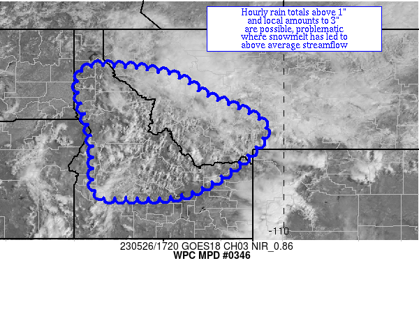
Areas affected...portions of Idaho & western Montana

Concerning...Heavy rainfall...Flash flooding possible

Valid 261740Z - 262340Z

Summary...Showers and thunderstorms with heavy rain are expected
to form within an anomalously moist air mass at elevation.  Hourly
rain totals occasionally eclipsing 1" with local 3" amounts are
possible, which would be an issue where snow melt is compounding
issues.

Discussion...Satellite imagery shows an enhanced cumulus field
with developing showers across elevated portions of ID and
adjacent western MT as daytime heating interacts with a relatively
moist atmosphere near a 700 hPa convergence zone east and north of
a pair of upper lows.  Precipitable water values are 0.6-0.9",
which is rather high for topography in the area and at least 1.5
sigmas above the norm for late May.  ML CAPE is rising, with
bubbles of 500+ J/kg across far western MT and southern ID.
Effective bulk shear is 25-30 kts.

The mesoscale guidance shows an isolated to widely scattered
signal for heavy rainfall across the region, with local amounts of
2-3" indicated on the 00z NSSL WRF, 12z NAM CONEST, and 12z ARW.
The degree of effective bulk shear could organize convection.
With ML CAPE likely to rise 1000+ J/kg today, hourly rain totals
could eclipse 1".  This would be a problem in areas where snow
melt is still occurring and where area creeks and rivers have
above average streamflow.  Heavy rain-related issues are expected
to be isolated to widely scattered.

Roth

ATTN...WFO...BOI...BYZ...MSO...OTX...PDT...PIH...TFX...

ATTN...RFC...MBRFC...NWRFC...NWC...

LAT...LON   47771624 47501385 46841270 45621062 43641289
            43391534 43591631 45241641 47211691
Last Updated: 141 PM EDT Fri May 26 2023
|


