| WPC Met Watch |
|
|
Mesoscale Precipitation Discussion: #0347 (2023) |
|
(Issued at 411 PM EDT Fri May 26 2023
) |
|
| MPD Selection |
|
|
|
|
|

Mesoscale Precipitation Discussion 0347
NWS Weather Prediction Center College Park MD
411 PM EDT Fri May 26 2023

Areas affected...Portions of the Central/Southern Rockies and High
Plains

Concerning...Heavy rainfall...Flash flooding possible

Valid 262010Z - 270210Z

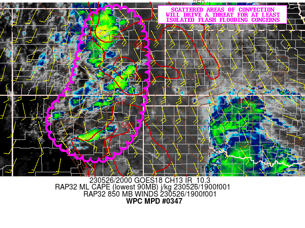
SUMMARY...Scattered areas of showers and thunderstorms developing
over the higher terrain of the central and southern Rockies will
advance gradually east through the afternoon and early evening
hours. Locally heavy rainfall will pose an isolated threat for
flash flooding.

DISCUSSION...The midday GOES-W IR satellite imagery shows
convective initiation well underway across the higher terrain of
the central and southern Rockies. The activity is at least
initially being driven by strong solar insolation and related
boundary layer destabilization coupled with terrain-induced
circulations and related orographic ascent. Additionally, the flow
aloft is rather divergent downstream of a slow-moving upper trough
over the Great Basin.

Over the next several hours, this activity should grow upscale a
bit more and attain greater organization while also advancing east
of the higher terrain and out into the open High Plains of
central/eastern CO and down through eastern NM. MLCAPE values are
locally already on the order of 1500+ J/kg with some room to grow
given the aforementioned solar insolation. The shear aloft is
rather modest over CO, but increases rather markedly down over
eastern NM with notably stronger wind profiles.

A combination of the strong thermodynamics and kinematics will
favor rather strong convection with at least elevated rainfall
rate potential. The rainfall potential is being aided by the
persistence of moist low-level south to southeast flow which is
also increasing the PW anomalies across the High Plains. The
latest RAP guidance supports these values reaching 1.5 to 2
standard deviations above normal by 00Z.

Rainfall rates may reach as high as 1.5+ inches/hour with the
stronger cells, and some spotty storm totals of 2 to 3+ inches
will be possible where potentially a few cell-mergers occur over
the next several hours along with brief instances of repeating
cell-activity. Locally over the higher terrain, there are some
burn scar sensitivities that need to be closely watched for
enhanced runoff potential. The more urbanized locations farther
off to the east will also be susceptible to a threat of flash
flooding should these stronger pockets of convection impact these
areas.

Orrison

ATTN...WFO...ABQ...BOU...GJT...GLD...PUB...

ATTN...RFC...ABRFC...CBRFC...MBRFC...WGRFC...NWC...

LAT...LON   40940395 40120313 37970293 35480341 34300446
            34100550 34650673 35290726 36300724 37470630
            39780574 40740524
Last Updated: 411 PM EDT Fri May 26 2023
|


