| WPC Met Watch |
|
|
Mesoscale Precipitation Discussion: #0349 (2023) |
|
(Issued at 645 PM EDT Fri May 26 2023
) |
|
| MPD Selection |
|
|
|
|
|

Mesoscale Precipitation Discussion 0349
NWS Weather Prediction Center College Park MD
645 PM EDT Fri May 26 2023

Areas affected...Central/Northern WY...Southeast MT...Western
ND...Far Northwest SD

Concerning...Heavy rainfall...Flash flooding possible

Valid 262245Z - 270445Z

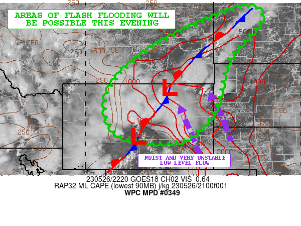
SUMMARY...Increasing coverage of heavy showers and thunderstorms
with concerns for localized cell-mergers and training
cell-activity should pose at least some flash flood threat going
into the evening hours.

DISCUSSION...Radar and satellite imagery shows multiple clusters
of heavy showers and thunderstorms impacting areas of central and
northern WY with coverage beginning to expand into far southeast
MT and across western ND. The convection is being strongly driven
by the arrival of a low-amplitude shortwave trough ejecting
downstream from the much larger scale trough over the Great Basin.

This energy is interacting interacting with a strongly unstable
boundary layer with MLCAPE values of 2000+ J/kg pooled up across
eastern WY and toward southeast MT. This is also with proximity of
a quasi-stationary front where at least some weak transient
surface wave activity is noted.

PWs are anomalously high across the region and locally 2+ standard
deviations above normal across eastern WY and into much of eastern
MT and the western Dakotas. This coupled with the instability and
a fair amount of low to mid-level shear will enhance the rainfall
potential, with some rainfall rates of 1.5 to 2 inches/hour with
the stronger storms.

Already the hires models from the 12Z HREF suite appear largely
slow with the convective evolution and underdone with their
amounts. However, recent HRRR runs have been trending a bit wetter
with their QPF signal for the evening hours.

The expectation is that the convection over the next few hours
will continue to grow upscale and especially up over areas of
southeast MT. Adjacent areas of western ND and even far northwest
SD near the Black Hills will also be a concern for areas of
slow-moving and locally concentrated convection. Some pockets of
cell-merger activity and cell-training will be possible.

Rainfall amounts going through the evening hours are expected to
locally reach 2 to 4 inches, with isolated heavier amounts to 5+
inches possible. Locally wet antecedent conditions and somewhat
elevated streamflows in conjunction with these additional rains
may facilitate some areas of flash flooding through this evening.

Orrison

ATTN...WFO...BIS...BYZ...CYS...GGW...RIW...UNR...

ATTN...RFC...MBRFC...NWC...

LAT...LON   48530262 48000181 46150336 44110387 43070456
            42350574 42540823 43660901 44910875 46200747
            47450539
Last Updated: 645 PM EDT Fri May 26 2023
|


