| WPC Met Watch |
|
|
Mesoscale Precipitation Discussion: #0418 (2023) |
|
(Issued at 528 PM EDT Sat Jun 03 2023
) |
|
| MPD Selection |
|
|
|
|
|

Mesoscale Precipitation Discussion 0418
NWS Weather Prediction Center College Park MD
528 PM EDT Sat Jun 03 2023

Areas affected...Southern High Plains

Concerning...Heavy rainfall...Flash flooding possible

Valid 032125Z - 040300Z

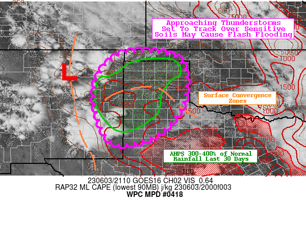
SUMMARY...Thunderstorms emerging off the southern Rockies will
track towards the southern High Plains. Excessive Rainfall rates
up to 2"/hr atop sensitive soils may result in flash flooding this
afternoon and evening.

DISCUSSION...Storms forming along the front range of the southern
Rockies of New Mexico will propagate east into an increasingly
unstable and moist environment. Surface observations also show a
surface trough located just north of Amarillo, which could also
serve as an ideal trigger for more storms this afternoon. RAP
mesoanalysis shows plenty of MLCAPE for approaching storms to work
with ranging as high as 1,000-2,000 J/kg. PWs are as low as 0.8"
in eastern New Mexico to as high as 1.1" near the TX/OK border. As
the 850mb moisture flux embedded within easterly flow out of
central Oklahoma increases tonight, the footprint of 1.0" PWs will
extend farther west, potentially all the way to the NM/TX border.
On the synoptic scale, the southern High Plains are favorably
positioned ahead of an anomalous upper trough over the Southwest.
The upper trough will foster healthy divergent flow atop the
atmosphere to allow for a more supportive environment for upscale
growth for strengthening convection.

Area averaged HRRR soundings along the TX/NM border and into the
heart of the TX Panhandle show that while instability is present,
lapse rates are steep enough that warm cloud layers will be
shallow. While this should limit these cells from displaying the
quintessential characteristics for efficient warm rainfall
processes, competing easterly low level winds, westerlies at
mid-levels, and southerlies at upper levels are causing mean cloud
layer steering winds to top out around 10 knots. Plus, the
region's soils remain quite sensitive after receiving 300-400% of
normal rainfall over the past 30 days according to AHPS. Slower
storm cell motions over areas with exceptionally saturated soils
is a recipe for a flash flood threat this afternoon and evening.
Poor drainage areas and the most sensitive of soils are most prone
to possible flash flooding, along with urbanized/higher
concentration of hydrophobic surfaces communities.

Mullinax

ATTN...WFO...ABQ...AMA...LUB...MAF...

ATTN...RFC...ABRFC...WGRFC...NWC...

LAT...LON   36880286 36860138 36430037 34740027 33480109
            32850216 32780357 34190429 35460430 36450371
Last Updated: 528 PM EDT Sat Jun 03 2023
|


