| WPC Met Watch |
|
|
Mesoscale Precipitation Discussion: #0420 (2023) |
|
(Issued at 900 PM EDT Sat Jun 03 2023
) |
|
| MPD Selection |
|
|
|
|
|

Mesoscale Precipitation Discussion 0420
NWS Weather Prediction Center College Park MD
900 PM EDT Sat Jun 03 2023

Areas affected...Central High Plains

Concerning...Heavy rainfall...Flash flooding possible

Valid 040100Z - 040400Z

SUMMARY...Line of thunderstorms containing hourly rainfall rates
up to 1.5"/hr may result in flash flooding, particularly in areas
with sensitive soils.

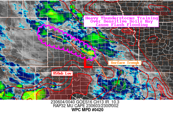
DISCUSSION...GOES-16 satellite imagery showed an ongoing cluster
of thunderstorms tracking ESE to WNW along a surface trough. The
850mb low remains continues to funnel low level moisture along the
trough with PWs as high as 1.5" in south-central Kansas. MUCAPE by
01Z will range between 500-1,000 J/kg in the highlighted region,
while area averaged soundings from the HRRR for 01Z show low-mid
level RH values of 85% and warm cloud layers up to 8,000 feet
deep. Corfidi upshear vectors remain around 10 knots and 1-hr FFGs
are still as low as 1.0-1.5" in western Kansas.

Most observed hourly rainfall rates have topped out below 1.5"/hr,
however MRMS 15-minute rates are still in the 0.6-0.8" range. MRMS
CREST Maximum Unit Streamflow also identified up to 100 cfs/smi in
areas hit by these cells over the last hour or two. Should storms
train over a location for an additional 1-2 hours, there could be
localized flash flooding to contend with this evening. Western
Kansas remains most prone to possible flash flooding given the
300-400% of normal rainfall totals there over the past 7-days.
Spots where soils are most saturated and sensitive, as well as
poor drainage areas have better odds to witness areas of flash
flooding over the next few hours.

Mullinax

ATTN...WFO...DDC...GLD...ICT...

ATTN...RFC...ABRFC...MBRFC...NWC...

LAT...LON   40260227 39820114 39350019 38359844 37709832
            37739883 38420038 38720155 39170251 39830267
Last Updated: 900 PM EDT Sat Jun 03 2023
|


