| WPC Met Watch |
|
|
Mesoscale Precipitation Discussion: #0422 (2022) |
|
(Issued at 853 AM EDT Fri Jul 01 2022
) |
|
| MPD Selection |
|
|
|
|
|

Mesoscale Precipitation Discussion 0422...Corrected
NWS Weather Prediction Center College Park MD
853 AM EDT Fri Jul 01 2022

Corrected for flash flooding category

Areas affected...Upper Texas Coast, Southwest Louisiana

Concerning...Heavy rainfall...Flash flooding likely

Valid 011229Z - 011730Z

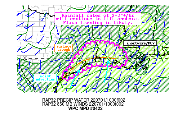
Summary...A weakening trough of low pressure will expand heavy
rainfall across the Upper Texas Coast and Southwest Louisiana into
this afternoon. Rainfall rates may exceed 3"/hr at times, which
through training will likely produce at least isolated flash
flooding.

Discussion...The combination of the GOES-E IR and WV imagery this
morning depicts an expanding area of cooling cloud tops along the
Western Gulf Coast in response to a mid level shortwave lifting
slowly northward along the TX/LA border. This mid-level shortwave
is also accompanied by a weak spin /MCV/ embedded within the
intensifying convection noted on the regional radar mosaic. This
is collocated with a surface trough that is the remnant of a
tropical disturbance that moved across the northern Gulf of Mexico
the past few days. Recent rainfall rate estimates from KHGX and
KLCH were as high as 2.5"/hr in this tropical environment, and
these rates should continue to expand across the region this
morning.

The thermodynamic environment is extremely favorable for heavy
rainfall. The 12Z U/A sounding out of KLCH measured a PW of 2.34",
with GPS observations indicating a pool of greater than 2.2" along
the Upper Texas coast, well above the 90th percentile and nearing
daily records. These PWs are supported by MLCape which has climbed
to as high as 1500 J/kg according to the SPC RAP analysis,
although the highest instability still lies south of the surface
trough and over the water. However, as the mid-level shortwave
pivots northward, it will drag the surface trough with it,
resulting in higher PWs and CAPE being drawn northward into TX and
LA. While this expansion of instability will likely lead to a
broadening of convective coverage, rain rates will continue to
surge to well above 2"/hr as shown by HREF probabilities reaching
60%, with local rain rates above 3"/hr also likely.

With storm motions expected to remain modest at 10-15 kts noted by
forecast 0-6km mean winds, and backbuilding into the greater
instability suggested by increasingly opposed Corfidi vectors,
many areas could receive several rounds of heavy rainfall. This
could be even more impressive where training can occur, especially
along any trailing convergent banding modeled by the high-res
guidance which could develop behind the MCV/shortwave and arc back
into the Gulf of Mexico. The high-res guidance is in decent
agreement in the footprint of heavy rain into the early aftn, with
local maxima of more than 5 inches likely as shown by the HRRR,
the TT WRF, and 6-hr HREF probabilities of more than 50%.

This will likely pose an increasing localized to scattered flash
flood threat as 850mb winds, despite being modest around 20 kts,
continue to exceed the 0-6km mean winds which are just 10-15 kts.
This combined with the slow net storm motion due to backbuilding
suggests both the 1-hr and 3-hr FFG, which range from 2.5-4",
could be exceeded. Recent antecedent dryness may somewhat limit
the scope of flash flooding, but in any urban areas, and where the
most pronounced training can occur with these excessive rain
rates, flash flooding is likely to occur.


Weiss

ATTN...WFO...CRP...HGX...LCH...LIX...SHV...

ATTN...RFC...LMRFC...WGRFC...NWC...

LAT...LON   31479333 31319243 30869152 30429112 30169103
            29689106 29399155 29499249 29559340 29469402
            29149484 28879525 28609573 28289617 28149642
            28179662 28309674 28599671 28949627 29329597
            29759579 30189549 30679507 31089464 31339423
Last Updated: 853 AM EDT Fri Jul 01 2022
|


