| WPC Met Watch |
|
|
Mesoscale Precipitation Discussion: #0437 (2019) |
|
(Issued at 1145 PM EDT Sun Jun 16 2019
) |
|
| MPD Selection |
|
|
|
|
|

Mesoscale Precipitation Discussion 0437
NWS Weather Prediction Center College Park MD
1145 PM EDT Sun Jun 16 2019

Areas affected...The Hill Country through the Upper Coast of Texas

Concerning...Heavy rainfall...Flash flooding possible

Valid 170344Z - 170944Z

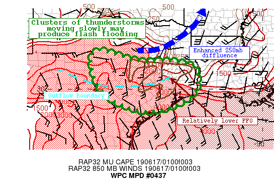
Summary...Clusters of thunderstorms will congeal into a larger
complex tonight producing a flash flood risk. Rain rates in excess
of 2"/hr are possible, and where storms merge or training occurs,
2-4" of rainfall is likely, with locally higher amounts possible.
This has the potential to produce flash flooding, especially
within urban areas, along any terrain, or where FFG is relatively
lowered due to antecedent rainfall.

Discussion...Clusters of thunderstorms have become more widespread
this evening beneath a mid-level trough moving overhead northern
Texas and Oklahoma. A remnant outflow boundary is evident on
regional radar mosaic as an arc of thunderstorms sinking slowly
southward across the area, while enhanced upper diffluence pointed
northward from OK/LA is evident by a cirrus channel on GOES-16 IR
imagery. All of these features together produce a chaotic
environment, but one that will remain highly favorable for
thunderstorms with heavy rainfall through the next several hours.

Recent RAP analyzed MUCape is still 3000-4000 J/kg with PWATs of
over 1.8 inches lifting into Texas. This moist advection is
occurring on an 850mb LLJ which will persist at 20-30 kts while
veering from SE to S. This LLJ will continue to pump moisture into
the region, with subsequent isentropic ascent atop any residual
outflows aiding in surface based lift due to the significant
instability. As PWATs continue to climb towards 2 inches, above
the 90th percentile for the date, and ascent remains robust in
response to both synoptic and mesoscale features, convection will
expand in coverage and likely organize in an environment with
effective bulk shear of 30-45 kts. The primary focus may continue
to be the large outflow sinking southward, and this is expected to
slow or even stall as 0-6km mean wind becomes less than 10 kts
from the west as it encounters the strengthening S/SE LLJ. RAP
Corfidi vectors are forecast to remain relatively fast, 15-20 kts,
but will feature a sharp angle to the right of the mean flow
suggesting backbuilding of cells will continue along and behind
this outflow. Where this occurs, the flash flooding threat will be
greatest.

Although some uncertainty into placement of the heaviest rainfall
remains in recent CAMs, there is good consensus for 2-4" of
rainfall due to rain rates which may exceed 2"/hr at times. Some
of this area is already primed for flash flooding due to previous
rainfall and lower FFG, urban affects (near Houston), or terrain
(along the Balcones Escarpment), and these are the locations which
have the highest chances for flash flooding. If training can occur
across these areas, flash flooding would be likely.

Weiss

ATTN...WFO...CRP...EWX...FWD...HGX...LCH...SHV...SJT...

ATTN...RFC...WGRFC...

LAT...LON   32219936 32219920 32069869 31899809 31729771
            31649741 31599719 31569676 31569657 31559619
            31579586 31599563 31599533 31449432 31329404
            31279397 31089381 31019379 30769371 30629369
            30439367 30169374 30009379 29829388 29659405
            29499429 29349457 29129491 28969532 28839591
            28779675 28989757 29339844 29819900 30409943
            31169967 31249969 31479973 31719974 31929971
            32089962 32189948
Last Updated: 1145 PM EDT Sun Jun 16 2019
|


