| WPC Met Watch |
|
|
Mesoscale Precipitation Discussion: #0473 (2024) |
|
(Issued at 316 PM EDT Thu Jun 20 2024
) |
|
| MPD Selection |
|
|
|
|
|

Mesoscale Precipitation Discussion 0473
NWS Weather Prediction Center College Park MD
316 PM EDT Thu Jun 20 2024

Areas affected...Central and Eastern SD...Far Northwest
IA...Southwest MN

Concerning...Heavy rainfall...Flash flooding possible

Valid 201915Z - 210115Z

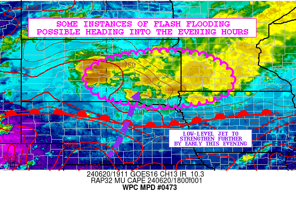
SUMMARY...A general increase in the concentration of showers and
thunderstorms can be expected this afternoon and evening. Heavy
rainfall coupled with increasingly moist antecedent conditions may
result in some areas of flash flooding by this evening.

DISCUSSION...A gradual strengthening of warm air advection through
the afternoon and evening hours coupled with the stronger
transport of moisture and instability in an elevated fashion along
and north of a warm front should encourage additional areas of
showers and thunderstorms to develop. GOES-E IR satellite imagery
already shows broken areas of cold-topped convection across areas
of southern and eastern SD, with some pockets of repeating
cell-activity.

MUCAPE values of locally 500 to 1000 J/kg are currently in place
near the active areas of convection, with positive 3-hourly MUCAPE
differentials continuing to increase with time. A southerly
low-level jet of 20 to 30 kts is nosing up across northern NE
toward southern SD, but this should increase in strength this
afternoon and especially early this evening to as much as 30 to
40+ kts.

PWs are forecast to increase to locally over 2 standard deviations
above normal with values reaching well over 1.5 inches by early
this evening across central and eastern SD along with adjacent
areas of northwest IA and southwest MN.

Subtle shortwave energy ejecting out of the High Plains will be
crossing the region over the next several hours and this will
interact with the increasingly favorable thermodynamic environment
associated with the strengthening warm air advection regime to
yield more expansive areas of convection that will also be
conducive for heavier rainfall rates.

The 12Z HREF supports rainfall rates reaching as high as 1.5
inches/hour, with some additional storm totals through 00Z (7pm
CDT) of 2 to 4 inches. Given the increasingly moist antecedent
conditions, there may be some areas of flash flooding by this
evening. A much more organized threat of heavy rain from strong
convection is expected late this evening and the overnight period,
and thus additional MPDs will be issued accordingly.

Orrison

ATTN...WFO...ABR...DMX...FSD...LBF...MPX...OAX...UNR...

ATTN...RFC...MBRFC...NCRFC...NWC...

LAT...LON   45349764 45209561 44529426 43619417 43029550
            42839731 42969873 43360030 44070095 44580067
            45069949
Download in GIS format: Shapefile
| KML
Last Updated: 316 PM EDT Thu Jun 20 2024
|


