| WPC Met Watch |
|
|
Mesoscale Precipitation Discussion: #0477 (2024) |
|
(Issued at 123 AM EDT Fri Jun 21 2024
) |
|
| MPD Selection |
|
|
|
|
|

Mesoscale Precipitation Discussion 0477
NWS Weather Prediction Center College Park MD
123 AM EDT Fri Jun 21 2024

Areas affected...Southwest SD...Southwest & South-Central
MN...Northwest IA...Ext Northeast NEB...

Concerning...Heavy rainfall...Flash flooding likely

Valid 210525Z - 211115Z

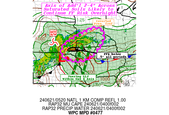
SUMMARY...Prolonged moderate rainfall within WAA with occasional
embedded bursts up to 2"/hr.  Additional 3-4" Totals across
saturated soils likely to continue broad area of flash flooding
conditions through early morning.

DISCUSSION...05z surface map depicts a meso-low along the leading
outflow boundary in proximity of the Missouri River Valley along
the NEB/SD line; a weakening outflow boundary extends southwest
across central NEB.  Eastward the warm/stationary front extends
nearly due east to SUX-EBS-MIW-VTI-MXO, which generally delineates
70+ Tds to the south.  Surface map also denotes a well defined
surface pressure trof that extends northeast across SE SD into SW
MN up to RWF-MIC/MGG; and generally appears to be a reflection of
the best mid to upper level divergence ascent pocket along the
southern entrance to the polar jet where ageostrophic winds are
increased for favorable evacuation.   As such, the MCV/shortwave
continues to track eastward into that axis and the LLJ seems to be
veering in response to it.  This is reducing the deep layer
convergence along the effective cold front/outflow boundary but
increasing orthogonal convergence to the frontal boundary within
increasing warm advective isentropic ascent.  Instability north
into MN had been slow to increase but with this veering MUCAPE
values are increasing back toward the 500-1000 J/kg range.  This
should support broken/scattered embedded convective elements
within the WAA isentropic ascent.

Given the LLJ is 30+kts and orienting through the Missouri Valley
where the Q-Axis resides allowing for upstream 1.75" total PWats
to replenish the 1.75-2" values between the pressure trof and
frontal zone downshear of the MCV into SW MN.  This will allow for
a broad long area of 1-1.5"/hr moderate rain-rates and where
convergence/instability maximize embedded thunderstorms capable of
2"/hr rates will occur.  The deep layer steering flow should allow
for an long west to east WAA axis for longer duration of this
moderate rainfall...mainly across SW MN with 3-4" totals in a
county wide swath.  Broader 1-3" totals surround for a surrounding
counties in south-central MN and Northwest IA.

This intersects saturated grounds where AHPS 7day anomalies are
300-400% between Sioux Falls and Minneapolis and 0-40cm saturation
ratios are 70-85% and well into the 80th-90th percentile; and this
is not to account for areas of SE SDAK/NW IA that had 2-4" earlier
today where FFG values remain below .5" at all time periods. So
with limited capacity and these totals, a broad axis of flash
flooding is likely to occur through the remainder of the overnight
period.

Gallina

ATTN...WFO...DMX...FSD...MPX...OAX...

ATTN...RFC...MBRFC...NCRFC...NWC...

LAT...LON   45189401 44989312 44369296 43459363 42619484
            42279618 42539784 43239835 43849771 44509633
            44899525
Download in GIS format: Shapefile
| KML
Last Updated: 123 AM EDT Fri Jun 21 2024
|


