| WPC Met Watch |
|
|
Mesoscale Precipitation Discussion: #0483 (2024) |
|
(Issued at 452 PM EDT Fri Jun 21 2024
) |
|
| MPD Selection |
|
|
|
|
|

Mesoscale Precipitation Discussion 0483
NWS Weather Prediction Center College Park MD
452 PM EDT Fri Jun 21 2024

Areas affected...southeastern SD...northeastern NE...southern
MN...northern IA

Concerning...Heavy rainfall...Flash flooding likely

Valid 212100Z - 220300Z

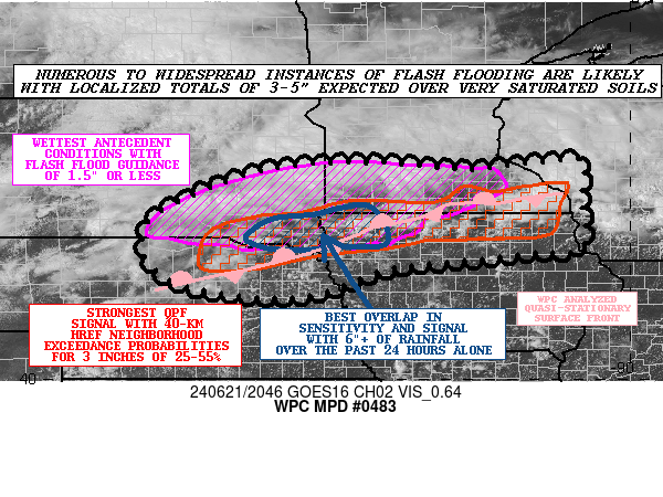
Summary...Numerous to widespread instances of flash flooding are
likely with localized totals of 3-5" expected over soils that are
already very saturated. Significant, life threatening flash
flooding is also possible (particularly where the wettest
antecedent conditions overlap with the strongest rainfall signal,
indicated by where the pink and red areas overlap in the graphic).

Discussion...Organized convection is set to proliferate once again
this evening over portions of the Northern/Central Plains and into
the Midwest, as a frontal zone remains draped across areas that
have already been soaked by days of heavy rains. The wettest
antecedent conditions (with corresponding Flash Flood Guidance of
1.5" or less) are across southeastern SD into northwestern IA and
southern MN (denoted by the pink outlined area in the graphic),
uncomfortably close to (and partially overlapping) a
quasi-stationary surface front (analyzed by WPC). Meanwhile, a
mid-level shortwave trough is evident (via GOES-East water vapor
imagery) just upstream (over western NE/KS and northeastern CO),
which should help to provide large scale lift for convection via
differential positive vorticity advection (DPVA). In addition, the
right-entrance region of a strong (100+ kt) jet streak should
provide additional large scale lift via upper-level divergence.
The parameter space is also quite impressive, as indicated by SPC
RAP analysis with The mesoscale environment is characterized by
ample instability (MUCAPE of 500-3000 J/kg), near record
tropospheric moisture (precipitable water values of 1.7-1.9
inches, around the max moving average per SPC sounding
climatology), and effective bulk shear of 35-55 kts.

Hi-res model guidance is (overall) in remarkably good agreement,
as the 12z HREF signal (probability matched mean QPF and 40-km
neighborhood exceedance probabilities) lines up well with hourly
HRRR runs (which in and of themselves have been quite consistent
in depicting the highest QPF near/along the analyzed surface
front). This swath of the highest potential QPF (denoted by the
red outlined are in the graphic) is likely to see areal average
QPF of 1-2" with localized totals of 3-5". Unfortunately there is
a fair amount of overlap with this QPF guidance and the very wet
antecedent conditions (including a limited area in the SD/MN/IA
border region that has seen 6"+ of rainfall over the past 24
hours), raising concerns for numerous to widespread flash flooding
impacts (including localized significant life threatening flash
flooding). That said, the trend in the hi-res guidance (prior to
the 12z cycle) has been to shift the highest QPF south, and if
this axis verifies even farther south than currently depicted
(which is not all that uncommon, as CAMs tend to have a northeast
bias in QPF in association with MCSs) then this would limit the
flash flood threat somewhat (both in terms of coverage and
intensity). The latest HRRR runs give some indication of a
potential southward shift in the highest QPF, depicting merging
cells that become cold pool dominate and propagate southward. Even
so, this propagation effect may be too little too late, as the
strongest cells are expected to be capable of 2-3"/hr rainfall
rates (which would only require a couple hours of residence time
to lead to the expected localized 3-5" totals). Should cells NOT
become cold pool dominate and result in longer-term
training/repeating over sensitive areas (which is NOT currently
indicated by the hi-res guidance), then widespread impacts would
be a distinct possibility (with scattered instances of significant
to catastrophic flash flooding).

Churchill

ATTN...WFO...ABR...ARX...DMX...FSD...LBF...MPX...OAX...UNR...

ATTN...RFC...MBRFC...NCRFC...NWC...

LAT...LON   44619100 43879103 42799100 42709196 42569313
            42329513 41729708 42099971 43250022 44239835
            44599618 44459337 44609175
Download in GIS format: Shapefile
| KML
Last Updated: 452 PM EDT Fri Jun 21 2024
|


