| WPC Met Watch |
|
|
Mesoscale Precipitation Discussion: #0539 (2018) |
|
(Issued at 1258 PM EDT Wed Jul 25 2018
) |
|
| MPD Selection |
|
|
|
|
|

Mesoscale Precipitation Discussion 0539
NWS Weather Prediction Center College Park MD
1258 PM EDT Wed Jul 25 2018

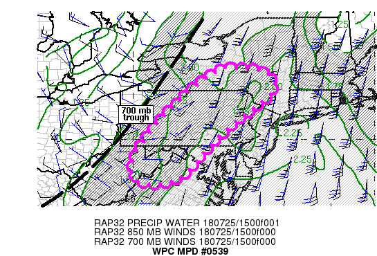
Areas affected...Northwestern VA, eastern WV, northwestern MD,
central PA into NY

Concerning...Heavy rainfall...Flash flooding likely

Valid 251657Z - 252255Z

Summary...Increasing coverage of thunderstorms with 1-2 in/hr rain
rates is expected across portions of the northern
Mid-Atlantic/central Appalachians into upstate NY through the
afternoon with localized maxima of 2-4 inches through 00Z.

Discussion...Visible satellite imagery as of 1630Z showed mostly
cloudy skies from the northern Mid-Atlantic states into NY, but
with some breaks and thinning of clouds in a few locations. These
breaks have allowed temperatures to come up a few degrees along
with MLCAPE values which were estimated to be between 500 and 1000
J/kg as of 16Z. With little to no CIN observed on 12Z soundings
from PIT and IAD to ALB, continued heating, especially with
further breaks in cloud cover, will allow for  increased coverage
of convection into the afternoon. Radar estimates and ground truth
across portions of PA have already showed 0.5 to 1.0 in/hr
rainfall rates.

The activity is occurring ahead of a cold front, with the upper
level reflection noted at 700 mb via VAD wind plots, with the 700
mb trough axis extending from central Lake Ontario into western WV
as of 16Z. Ahead of this boundary, precipitable water values
remain high (1.8 to 2.2 inches) which will help to support heavy
rain rates. While stronger low level flow exists across northern
PA into NY, better able to support training cells, flash flood
guidance is an inch or less in 3 hours across a large region from
southern upstate NY into portions of central PA and northern VA/MD.

While the expected coverage of 1-2 in/hr rain rates is expected to
be scattered across the MPD threat area, the risk for excessive
rainfall amid saturated soils is high, thus warranting the
"likely" flash flood category.

Otto

ATTN...WFO...ALY...BGM...CTP...LWX...PBZ...PHI...RLX...

ATTN...RFC...MARFC...NERFC...OHRFC...

LAT...LON   42917536 42827477 42427415 41767444 41107528
            40247633 39367716 38347818 38237969 39107999
            40617900 41677795 42347720 42897628
Last Updated: 1258 PM EDT Wed Jul 25 2018
|


