| WPC Met Watch |
|
|
Mesoscale Precipitation Discussion: #0546 (2021) |
|
(Issued at 910 AM EDT Thu Jul 15 2021
) |
|
| MPD Selection |
|
|
|
|
|

Mesoscale Precipitation Discussion 0546
NWS Weather Prediction Center College Park MD
910 AM EDT Thu Jul 15 2021

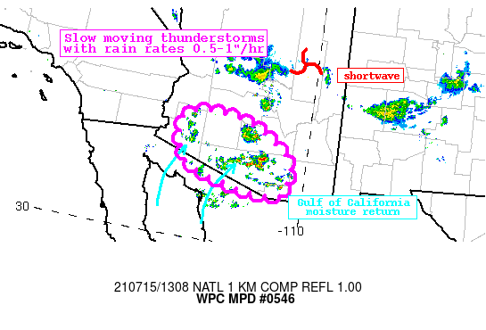
Areas affected...Southern Arizona

Concerning...Heavy rainfall...Flash flooding possible

Valid 151309Z - 151800Z

Summary...Morning thunderstorms developing across Arizona will
drop only slowly southward through late morning. Rainfall rates
may reach 1"/hr at times in the saturated environment. Flash
flooding is possible.

Discussion...The regional radar mosaic this morning depicts
thunderstorms blossoming quickly across parts of southern Arizona.
These thunderstorms are developing in response to both a shortwave
dropping southward through a weakness in the mid-level ridge over
northern AZ, and along an 850-700mb confluence boundary evident on
the RAP mesoanalysis from SPC. The 12Z U/A sounding at TUS and PSR
measured PWs of 1.75 and 1.95 inches, respectively, both well
above the 90th percentile for the date. This high PW is thanks in
part to robust moist advection lifting northward out of the Gulf
of California on 20-30 kts of 850mb flow.

MUCape across the area is as high as 2000 J/kg already this
morning thanks to steep lapse rates above the surface with an
exceptionally moist layer between 850 and 500mb on the morning
soundings. The thickest CAPE extends above -10C, so while warm
rain processes are not likely to dominate, heavy convective
rainfall due to robust updrafts are likely, and the 06Z HREF
probabilities indicate a 20% chance for 1"/hr rates through early
aftn, matching well pockets of current radar estimated rates
greater than 1"/hr. Although shear is minimal indicating pulse
type convection will be predominant, weak mean 850-300mb winds of
just 5-10 kts combined with a sharp speed convergence axis at
850-700 mb suggests some brief organization is possible along
outflows, mergers, and this convergence axis. Additionally, storm
development will be aided by the southward advancing shortwave and
modest upper diffluence to enhance large scale ascent.

The 00Z high-res suite is modest in its evolution through the late
morning which limits confidence in the flash flood threat.
However, slow moving thunderstorms with rain rates around 1"/hr
could pose isolated flash flood problems. This is especially true
where FFG is less than 1"/1hr, or across any sensitive terrain or
urban areas. The HREF additionally indicates up to a 30% chance
for exceedance of both the 1-hr and 3-hr FFG, so despite limited
model agreement for the next several hours, there exists at least
an isolated threat for flash flooding through the morning, with a
greater chance developing beyond this MPD time period into the
aftn.

Weiss

ATTN...WFO...PSR...TWC...

ATTN...RFC...CBRFC...NWC...

LAT...LON   33371314 33311236 33151176 32961133 32671091
            32381056 32051045 31931048 31581055 31411074
            31401114 31411145 31461202 31631268 31681293
            31841345 32101383 32531400 32951408 33161401
            33291378
Last Updated: 910 AM EDT Thu Jul 15 2021
|


