| WPC Met Watch |
|
|
Mesoscale Precipitation Discussion: #0578 (2023) |
|
(Issued at 102 PM EDT Sun Jun 25 2023
) |
|
| MPD Selection |
|
|
|
|
|

Mesoscale Precipitation Discussion 0578
NWS Weather Prediction Center College Park MD
102 PM EDT Sun Jun 25 2023

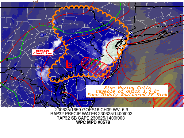
Areas affected...Eastern PA...Northeast MD...Far Northern DE...New
Jersey...Southern NY...

Concerning...Heavy rainfall...Flash flooding possible

Valid 251700Z - 252300Z

SUMMARY...Strong slow moving thunderstorms capable of 1.5-2"/hr
with potential for cell mergers/collisions by mid-afternoon pose
localized flash flooding potential near urban locales and areas
with saturated soils over the past few days.

DISCUSSION...GOES-E WV suite depicts the remaining small/compact
closed low along the eastern portion of the Mason-Dixon line,
still wobbling eastward.  Along the eastern hemisphere, weak but
sufficient DPVA and slightly cooler temps aloft have enhanced
instability given ample surface heating this morning and lingering
lower 70s dewpoints.  Total moisture has scoured a bit but remains
about 1.75" and temps climbing into the mid to upper 80s, SBCAPEs
have risen to above 2000 J/kg.  The profile supports warm cloud
process and limited evaporation given the high humidity through
400mb in proximity soundings suggesting continued highly efficient
rainfall production with 1.75-2"/hr rates becoming more likely
with peak unstable environment over the next few hours.

Currently, sea-breeze along the Jersey shore as activated vigorous
updrafts which is now expanding northward toward the NYC metro.
Given deeply stacked low, steering flow is limited and cells are
likely to be more pulse in nature given limited bulk shear for
organized structure. This will allow for highly localized heavy
rainfll cores with 1.5-2" falling in sub-hourly to hourly time
frames.  Propagation along outflow boundaries and additional
scattered development in the northeast quadrant of the upper-low
will also have increasing potential for cell mergers or more
likely outflow boundary collisions that may allow for broader
up/downdrafts covering slightly larger localized areas.

Flash flooding is not likely to be an issue across the Pine
Barrens (where cells are currently located), but locations along
the I-95 corridor, especially near Philadelphia, Baltimore and
Wilmington DE having seen recent heavy rainfall and flash flooding
conditions remain most susceptible to enhanced runoff and flash
flooding again today.  However, expansion into the Poconos,
southern Catskills and nearer NYC metro may have spots of 2-3"
totals as well resulting in low end flash flooding or quick urban
flooding concerns.

Gallina

ATTN...WFO...BGM...CTP...LWX...OKX...PHI...

ATTN...RFC...MARFC...NERFC...NWC...

LAT...LON   41967533 41937511 41557437 41147386 40597394
            39557463 39437500 39467528 39447587 39217657
            39587671 40387603 41077646 41527658 41927625
Last Updated: 102 PM EDT Sun Jun 25 2023
|


