| WPC Met Watch |
|
|
Mesoscale Precipitation Discussion: #0595 (2020) |
|
(Issued at 1030 AM EDT Tue Aug 04 2020
) |
|
| MPD Selection |
|
|
|
|
|

Mesoscale Precipitation Discussion 0595
NWS Weather Prediction Center College Park MD
1030 AM EDT Tue Aug 04 2020

Areas affected...Eastern Pennsylvania and Eastern New York

Concerning...Heavy rainfall...Flash flooding likely

Valid 041430Z - 041930Z

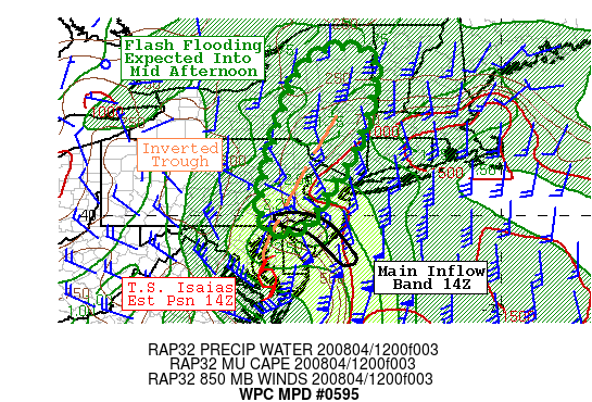
SUMMARY...Tropical Storm Isaias will advance rapidly
north-northeast across the western Delmarva Peninsula through
midday and along the PA/NJ line this afternoon. Particularly heavy
rainfall will continue along a trough ahead of Isaias currently
over far eastern PA that will lift across eastern NY this
afternoon, including the metro areas of eastern PA including
Philadelphia and the Catskills. Significant and potentially
life-threatening flash flooding remains likely.

DISCUSSION...The center of Isaias is estimated to be over
Dorchester Co MD at 14Z, continuing to accelerate north-northeast
ahead of a closed low over the northern Great Lakes. One main
convective band is wrapping around the northeastern flank of the
circulation over southern NJ into the Philly metro as very strong
moisture convergence and instability (generally 500 to 1000 J/kg
MUCAPE) transport works in tandem with strong shear profiles for
highly organized convection with embedded supercell structures.

Regional radar imagery shows an extensive axis of heavy rainfall
extending well north-northeast of Tropical Storm Isaias from
northeast MD and across eastern PA as strong deep layer ascent
fostered by the right-entrance region of an upper jet dynamics
overlaps with the aforementioned instability moisture/transport
and a surface inverted trough up across the northern Mid-Atlantic
coastal plain ahead of Isaias.

The heaviest rainfall will continue to be where the inflow band
meets the inverted trough axis. In the past hour 2 to 2.5 inches
have fallen (per KDIX) over northeast MD/northern DE. This area
will spread north across eastern PA into western NJ which is where
1 to 3 inches of rain have already fallen in association with the
leading inverted trough.

Extremely heavy rainfall rates of 2 to 3 inches/hr will continue
where the inflow band meets the trough. And despite the
accelerating nature of Tropical Storm Isaias, there is expectation
of additional areal rainfall amounts of 2 to 4 inches with
isolated additional amounts of 6 inches along the path of the
storm in the discussion area. Flash flooding is highly likely,
with some of it significant, and potentially life-threatening.
Most impacted areas are the many metro areas of eastern PA, the
Catskills and the southern Adirondacks later this afternoon.

Jackson

ATTN...WFO...ALY...BGM...BTV...BUF...CTP...OKX...PHI...

ATTN...RFC...MARFC...NERFC...NWC...

LAT...LON   44217346 42997348 41547402 40527471 39787517
            39777618 41487606 44077503
Last Updated: 1030 AM EDT Tue Aug 04 2020
|


