| WPC Met Watch |
|
|
Mesoscale Precipitation Discussion: #0600 (2023) |
|
(Issued at 1200 PM EDT Wed Jun 28 2023
) |
|
| MPD Selection |
|
|
|
|
|

Mesoscale Precipitation Discussion 0600
NWS Weather Prediction Center College Park MD
1200 PM EDT Wed Jun 28 2023

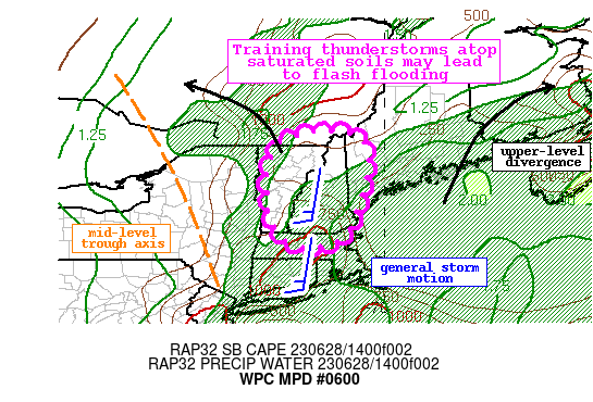
Areas affected...Parts of New England

Concerning...Heavy rainfall...Flash flooding possible

Valid 281600Z - 282200Z

Summary...Showers and thunderstorms will train from south to north
across central and northern New England through this evening.
Rainfall rates may exceed 2"/hr at times, and instances of flash
flooding are possible.

Discussion...The regional radar mosaic early this aftn shows
showers and isolated thunderstorms increasing in coverage from
Upstate New York though much of central New England. This
convection is blossoming in response to increasing deep layer
ascent downstream of mid-level height falls accompanying a trough
axis and increasing upper divergence as a jet streak pivots
northward. At the surface, low-level flow is nearly unidirectional
from the south on morning U/A soundings, transporting PWs
northward that were measured at 1.64 inches at OKX and 1.41 inches
at GYX, nearing the 90th percentile according to the SPC sounding
climatology. While the GYX sounding indicated some mid-level dry
air to overcome, the column was deeply saturated at OKX with
modest lapse rates and 12000 ft freezing levels, indicating
efficient rain processes. Clouds beginning to break has allowed
SBCAPE to reach 1000 J/kg according to the SPC RAP, furthering the
convective intensity, reflected by estimated rainfall rates of
1.5"/hr from KBOX last hour.

The mid-level trough will continue to pinwheel to the east today
while a modest shortwave noted in WV imagery swings through its
base. These together will impinge into an increasingly favorable
thermodynamic environment as the unidirectional southerly flow
drives PWs to as high as 1.75 inches and MUCAPE to around 2000
J/kg. This impressive overlap of forcing and moisture will produce
widespread convection this aftn/eve with rainfall rates likely
eclipsing 2"/hr as shown by HREF probabilities. Despite 0-6km mean
winds of 15-20 kts indicating fast forward propagation, aligned
Corfidi vectors suggest an enhanced threat for training and even
some backbuilding into the greater instability. With deep
unidirectional flow in place, any weak convergence signatures
could also produce more coherent lines of convection, and the HRRR
sub-hourly fields indicate a threat for up to 1" of rain in just
15 minutes today. Where these lines train most efficiently, a few
areas could receive 2-4" of rainfall.

Much of New England has been wet recently noted by 14-day rainfall
departures that are 150-300% of normal according to AHPS. This has
pre-conditioned the soils resulting in extremely anomalous stream
flows well above the 90th percentile, and FFG as low as 1"/3hrs
which has a 20-40% of being exceeded. These antecedent conditions
combined with sensitive terrain suggest an enhanced runoff risk
today, so training of any intense rainfall could produce flash
flooding.


Weiss

ATTN...WFO...ALY...BOX...BTV...GYX...

ATTN...RFC...NERFC...NWC...

LAT...LON   45367189 45357098 45057049 44677045 44127050
            43487067 43417069 42967087 42637107 42577113
            42397157 42347215 42517260 42807284 43197306
            43797309 44257310 44687301 45097275
Last Updated: 1200 PM EDT Wed Jun 28 2023
|


