| WPC Met Watch |
|
|
Mesoscale Precipitation Discussion: #0606 (2019) |
|
(Issued at 857 AM EDT Mon Jul 15 2019
) |
|
| MPD Selection |
|
|
|
|
|

Mesoscale Precipitation Discussion 0606
NWS Weather Prediction Center College Park MD
857 AM EDT Mon Jul 15 2019

Areas affected......Eastern MS TO Adjacent western AL and
southwest TN...

Concerning...Heavy rainfall...Flash flooding possible

Valid 151300Z - 151900Z

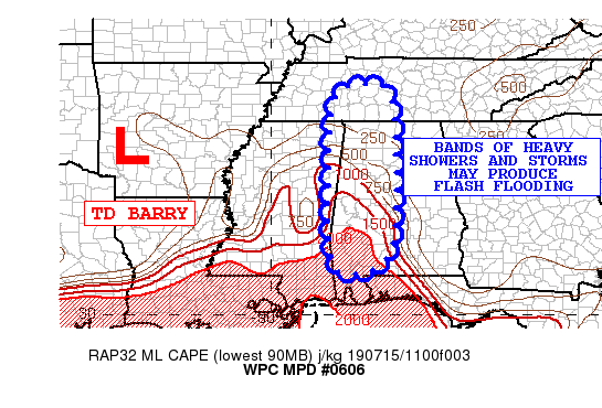
SUMMARY...A band of heavy showers/storms is expected to move
slowly east from eastern MS to western AL and southwest TN...

DISCUSSION...The latest radar imagery shows a training convective
band with very heavy showers and thunderstorms in eastern MS.
The showers and storms are producing rainfall rates of 1-2 inches
per hour with peak rates briefly higher.

The band of heavy showers and thunderstorms is oriented in a zone
of confluent low-mid level flow between TD Barry and a high
further east over the southeast, and also along the axis of
instability.  The current SPC mesoanalysis at 12z indicated mixed
layer CAPE values of 1-2 kj/KG across eastern MS.

The area is also experiencing persistent low-mid level moisture
fluxes.  The observed downstream sounding in Birmingham had 1.7
inches of precipitable water while the upstream Jackson MS
sounding had 2.2 inches of precipitable water.
The continuing low-mid level southerly flow should continue to
increase available moisture to the band, and the 11z RAP is
forecasting best lifted indices of -3 to -6 along the front flank
of the band, so confidence is high the band will persist over the
next several hours.

RAP forecast soundings show a gradual veering of the flow with a
southwest component 850-700 mb this afternoon, supporting a
forward propagation.

The 00Z hires models have struggled to pick up on the band so are
not likely to be helpful in discerning amounts, with the models
forecasting the primary band further southwest over LA.
Rainfall amounts of 2 to 4 inches are likely through eearly
afternoon, with locally heavier totals. One report of 2.4 inches
in the past six hours was observed at Bruce, MS.

Flash flooding is possible where training results in locally heavy
totals.

Petersen

ATTN...WFO...BMX...HUN...JAN...MEG...MOB...OHX...

ATTN...RFC...LMRFC...OHRFC...SERFC...

LAT...LON   35878708 35048684 34018678 33018678 31408701
            31228835 34068848 35758824
Last Updated: 857 AM EDT Mon Jul 15 2019
|


