| WPC Met Watch |
|
|
Mesoscale Precipitation Discussion: #0609 (2019) |
|
(Issued at 227 PM EDT Mon Jul 15 2019
) |
|
| MPD Selection |
|
|
|
|
|

Mesoscale Precipitation Discussion 0609
NWS Weather Prediction Center College Park MD
227 PM EDT Mon Jul 15 2019

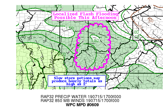
Areas affected...Central/Eastern KY...Ohio...Eastern Indiana

Concerning...Heavy rainfall...Flash flooding possible

Valid 151826Z - 160026Z

Summary...Slow moving thunderstorms within an anomalously high
moisture environment will be capable of producing hourly totals as
high as 2" and could lead to localized flash flooding.

Discussion...18Z mesoanalysis showed differential heating boundary
across portions of the lower Ohio Valley from east-central
Kentucky through western Ohio, eastern Indiana. GOES-East visible
satellite imagery showed building/towering cumulus and latest IR
imagery suggested cloud tops beginning to rapidly cool. Recent
radar imagery from KJKL, KILN, and KLVX showed nearly stationary
convection across the northern Bluegrass region of Kentucky
northward toward the greater Cincinnati area. with rain rate
estimates of 1.5 to locally 2"/hr.

Instability remains favorable with an axis of 2000-3000 J/kg of
SBCAPE across the outlook area. This is within a gradient of
higher PWs of 1.7 to 1.8" per recent RAP mesoanalysis. Overall
soundings show fairly weak, light steering flows which suggested
slower storm motions and the mean flow is generally aligned with
the favored storm motion which might lead to some training.
Through the next 6 hours, the hi-res guidance shows spotty higher
rain totals of 2-3" with locally higher amounts near 4" possible,
mainly across the Bluegrass region into southwest Ohio and
southeast Indiana.

Although the area has been drier than normal in the last 7 days,
the intense rain rates and slow storm motions over some sensitive
areas (low crossings, urban areas, etc) suggest some localized
potential for flash flooding through this afternoon during the
peak heating time.

Taylor

ATTN...WFO...CLE...ILN...IND...IWX...JKL...LMK...RLX...

ATTN...RFC...OHRFC...

LAT...LON   41148396 40758313 40428295 38758292 37568327
            37218372 37078467 37378580 38488582 39078573
            40128557 40718522
Last Updated: 227 PM EDT Mon Jul 15 2019
|


