| WPC Met Watch |
|
|
Mesoscale Precipitation Discussion: #0614 (2019) |
|
(Issued at 640 AM EDT Tue Jul 16 2019
) |
|
| MPD Selection |
|
|
|
|
|

Mesoscale Precipitation Discussion 0614
NWS Weather Prediction Center College Park MD
640 AM EDT Tue Jul 16 2019

Areas affected...Arkansas...Far Northwest MS...Far Western TN...MO
Bootheel

Concerning...Heavy rainfall...Flash flooding likely

Valid 161040Z - 161640Z

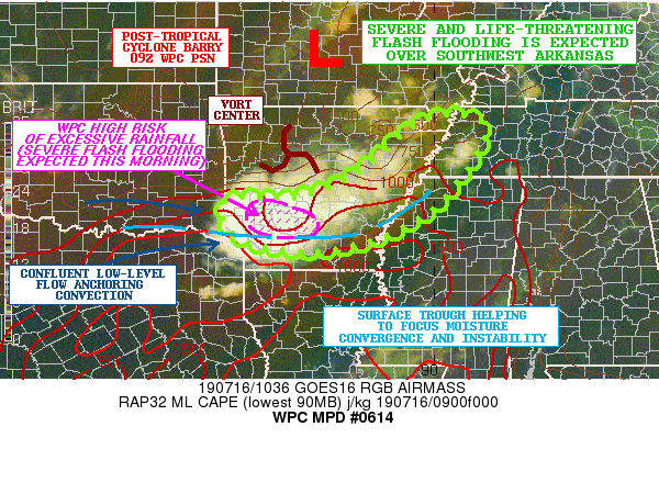
SUMMARY...Heavy showers and thunderstorms will continue to focus
around the far southern flank of Post-Tropical Cyclone Barry with
a tendency to backbuild and train over the same area. This coupled
with extremely heavy rainfall rates will result in flash flooding.
The situation will be particularly dangerous across southwest
Arkansas where the heaviest rainfall is expected which will likely
result in severe and life-threatening flash flooding for this area.

DISCUSSION...The latest GOES-16 Airmass RGB imagery shows a
well-defined and compact vort center dropping south-southeast
toward the base of the upper trough associated with Post-Tropical
Cyclone Barry. This energy is interacting with a surface trough
where a well-defined axis of moisture convergence has set up and
including a notable instability gradient.

The 00Z/06Z HREF suite of guidance, and the last several runs of
the HRRR, along with the experimental 06Z WoFS NSSL model output
have been showing a very strong signal for heavy showers and
thunderstorms to focus in a highly concentrated fashion across
southwest AR, and to some extent farther east with more broken
banding features impacting central to eastern AR, the MO Bootheel,
far northwest MS and into far western TN.

The PWATs are on the order of 2.0 to 2.25 inches and will be
conducive for generating enhanced rainfall rates as high as 3 to
4+ inches/hr given a deep column of tropical moisture per the
latest CIRA-LPW data analysis. The heaviest rates will be over
southwest AR where deep cold-topped convection with overshooting
tops are likely.

Over the next several hours, convection will be organized and
focused in a general west/east fashion across southwest AR and in
an environment conducive for backbuilding and training convective
cells given the relationship of the 850 mb flow (W-SW at 20 to 30
kts) relative to 850/300 mb mean layer (W at 10 to 20 kts). This
is supported by all of the available 00Z/06Z hires guidance, the
HRRR guidance and earlier runs of the experimental NSSL-WoFS
guidance. Elsewhere, there will be sufficiently confluent
low-level flow and instability for at least broken convective
bands which will tend to have a bit more progression.

Expect additional rainfall totals of 4 to 8 inches this morning
across parts of southwest AR, with isolated storm totals through
midday in excess of 10 inches expected. Elsewhere, additional
rainfall amounts of as much as 2 to 4 inches can be expected with
locally heavier totals.

Consequently, a high-impact and life-threatening flash flood event
is expected this morning across southwest AR in particular. This
is a very dangerous situation. For areas of central/eastern AR,
far western TN, northwest MS, and the MO Bootheel, there will be a
threat for broken areas of flash flooding based on the wet
antecedent conditions alone and additional rainfall potential.

Orrison

ATTN...WFO...JAN...LZK...MEG...SHV...

ATTN...RFC...ABRFC...LMRFC...

LAT...LON   36288925 35878892 34618975 33949069 33559173
            33449294 33659397 33999442 34449448 34569426
            34559393 34589286 34999176 35589104 36209019
Last Updated: 642 AM EDT Tue Jul 16 2019
|


