| WPC Met Watch |
|
|
Mesoscale Precipitation Discussion: #0631 (2018) |
|
(Issued at 406 AM EDT Sat Aug 11 2018
) |
|
| MPD Selection |
|
|
|
|
|

Mesoscale Precipitation Discussion 0631
NWS Weather Prediction Center College Park MD
406 AM EDT Sat Aug 11 2018

Areas affected...portions of the northern Mid-Atlantic into New
England

Concerning...Heavy rainfall...Flash flooding possible

Valid 110802Z - 111400Z

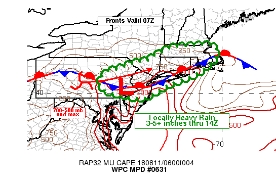
Summary...Flash flooding will be possible early this morning
across portions of the northern Mid-Atlantic into the NYC metro
and New England. Localized totals of 3-5 inches are expected,
possibly higher, through 14Z.

Discussion...07Z surface observations placed a wavy stationary
front from southern New England, southwestward across Long Island
to a weak low in eastern PA, and then westward into OH. Long loops
of regional radar reflectivity and GOES 16 5-minute low and
mid-level water vapor imagery showed the presence of a vorticity
max over south-central PA at 07Z, tracking toward the
east-northeast. Over the past hour, convection has begun to
increase ahead of this feature in eastern PA, with more scattered
activity downstream near the frontal boundary from Long Island
into southern New England. The SPC mesoanalysis from 07Z showed
MUCAPE across southern New England was weak ranging between 250
and 750 J/kg, with values increasing toward the southwest into the
1000-2000 J/kg range in eastern PA. RAP analysis soundings showed
tall/skinny CAPE profiles across the region with GPS based
precipitable water values ranging between 1.7 and 1.8 inches from
eastern PA into southern New England.

As forcing for ascent increases ahead of the aforementioned
mesoscale vorticity max and larger-scale shortwave trough over
WV/western PA, scattered showers and thunderstorms will increase
across eastern PA, NJ, the NYC metro and southern New England. Of
particular concern is the 850-300 mb mean-layer flow of 10-20 kt
being parallel to the 850-700 mb wind and the frontal boundary
extending from NJ into southern New England supporting the
potential of heavy rain cores stalling in the vicinity of the
frontal boundary with potential for rainfall rates near 3 in/hr.
While expected to be localized, stalling of heavy rainfall cores
could produce 3-5 inches of rain through 14Z, with some of the
better performing hi-res model guidance compared to observed radar
(00Z ARW, NSSL, NAM_nest) supporting over 6 inches of rain from
Long Island into CT by 14Z. These totals alone would be
problematic for flash flooding, but when coupled with recent
200-600 percent of normal rainfall for some locations over the
past week, the chances of flash flooding are even greater.

Otto

ATTN...WFO...ALY...BGM...BOX...CTP...GYX...OKX...PHI...

ATTN...RFC...MARFC...NERFC...

LAT...LON   42737098 42717048 42427034 41867050 41077154
            40437316 39937397 39727442 39727494 39897563
            40157664 40557691 41187656 41327596 41697492
            41837421 42077392 42287343 42507300 42647240
            42677157
Last Updated: 406 AM EDT Sat Aug 11 2018
|


