| WPC Met Watch |
|
|
Mesoscale Precipitation Discussion: #0634 (2020) |
|
(Issued at 512 AM EDT Fri Aug 14 2020
) |
|
| MPD Selection |
|
|
|
|
|

Mesoscale Precipitation Discussion 0634
NWS Weather Prediction Center College Park MD
512 AM EDT Fri Aug 14 2020

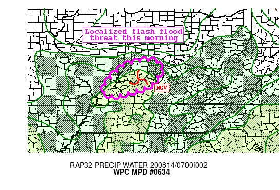
Areas affected...Southern Indiana, Northwest Kentucky

Concerning...Heavy rainfall...Flash flooding possible

Valid 140911Z - 141400Z

Summary...An MCV associated with expanding convection will drift
slowly N/NW through the morning. Rainfall rates in excess of 2"/hr
will accompany this feature. Localized flash flooding is possible.

Discussion...Morning radar imagery from KLVX WSR-88D shows an
expanding area of heavy rain with embedded convective elements,
and a broad rotational signature indicative of an MCV. Over the
past hour, rain rates have intensified to be estimated to be
1.5-2"/hr at times, and a few flash flood warnings have been
issued for the area. Although small scale, the slow movement of
this feature could produce torrential rainfall of 1-3" with
locally higher amounts over the next few hours.

This MCV is embedded within a broad mid-level trough with weak
steering flow. Mean winds from the RAP are generally 5 kts or less
to the N/NW, suggesting the MCV and its associated convection will
drift slowly in that direction. At the same time, a weak shortwave
dropping southeast into the trough could interact with the MCV
later this morning to persist thunderstorms even as the best
moisture confluence shifts away from the area. The high-res
guidance has been slow to pick up on this threat, but recent runs
of the HRRR show a localized threat continuing for a few hours as
PWs rise to above 2", which would be near the daily record. This
MCV may also lift along a narrow ribbon of 500-1000 J/kg of
MUCape, sufficient instability for heavy rain rates to persist in
the presence of this forcing.

Slow storm motions and propagation vectors aligned against the
weak mean flow indicate the potential for backbuilding, and HREF
hourly rain rate probabilites show low chances for 2"/hr rates
continuing to produce 1-3" of rainfall with locally higher
amounts. FFG in this region is generally 2"/1hr or 2.5"/3hrs,
which could be exceeded. The spatial extent of flash flooding
should be rather small, but the favorable thermodynamics and slow
moving storms suggest flash flooding is possible through the late
morning.


Weiss

ATTN...WFO...ILX...IND...LMK...PAH...

ATTN...RFC...LMRFC...OHRFC...NWC...

LAT...LON   39038637 38898580 38588558 38248570 37958593
            37698619 37538651 37438692 37308727 37168776
            37098829 37188870 37608868 38398800 38738752
            38938690
Last Updated: 512 AM EDT Fri Aug 14 2020
|


