| WPC Met Watch |
|
|
Mesoscale Precipitation Discussion: #0634 (2023) |
|
(Issued at 549 AM EDT Tue Jul 04 2023
) |
|
| MPD Selection |
|
|
|
|
|

Mesoscale Precipitation Discussion 0634
NWS Weather Prediction Center College Park MD
549 AM EDT Tue Jul 04 2023

Areas affected...southern NY/Long Island into central/southern New
England

Concerning...Heavy rainfall...Flash flooding likely

Valid 040946Z - 041545Z

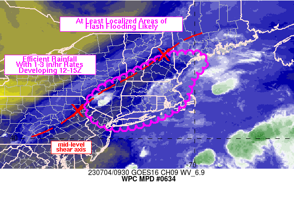
SUMMARY...A very isolated flash flood threat across southern NY
into New England is expected to increase in probability and
coverage after 12Z. Slow moving cells will be capable of producing
rainfall rates of 1-3 in/hr. While the coverage of these higher
rates may be somewhat limited, recent heavy rainfall across New
England makes the probability of at least localized flash flooding
likely through 16Z.

DISCUSSION...Regional radar imagery at 09Z showed a small area of
thunderstorms just north of I-84 along the PA/NY border. A second
area of showers, with recent weakening, was noted along the
southern NH/ME border. Both areas have had observed rainfall rates
of ~0.5-1.0 inches in 15 minutes, a testament to the efficiency of
rainfall generation within the environment. According to the 09Z
SPC mesoanalysis, precipitable water values ranged from 1.7 to 2.0
inches from the northern Mid-Atlantic region into central New
England, along with weak MLCAPE of ~500-1000 J/kg. However, high
surface dewpoints in the upper 60s to lower 70s has supported
limited to negligible low level convective inhibition across most
locations across the region.

A shear axis extending from central New England into east-central
PA with Weak mid-level vorticity maxima along and ahead of the
shear axis was observed on 6.9 micron water vapor imagery, with
forecast movement toward the east over the next 6 hours. Forcing
ahead of this mid-level feature along with daytime heating
(despite cloud cover) should be enough to generate an increasing
coverage of thunderstorms after 12Z, and especially by 15Z, over
southern New England. Weak steering flow from the Lower Hudson
Valley into southern VT/NH/ME will support slow moving cells with
high rainfall rates. Farther south, while deeper-layer mean winds
are a bit stronger at 10-15 kt, 850 mb winds increase with
southward extent...increasing the potential for training of cells.
Rainfall of 0.5 to 1.0 inches in 15 minutes and peak hourly
rainfall of 2-3 inches will be possible, some of which could fall
on top of saturated soils from recent heavy rain over the past few
days. At least localized areas of flash flooding are considered
likely.

Otto

ATTN...WFO...ALY...BGM...BOX...BTV...GYX...OKX...PHI...

ATTN...RFC...MARFC...NERFC...NWC...

LAT...LON   44006973 43536951 42857013 41677057 40797223
            40517356 40717447 41357508 42227464 43117294
            43937126
Last Updated: 549 AM EDT Tue Jul 04 2023
|


