| WPC Met Watch |
|
|
Mesoscale Precipitation Discussion: #0661 (2022) |
|
(Issued at 229 PM EDT Wed Aug 03 2022
) |
|
| MPD Selection |
|
|
|
|
|

Mesoscale Precipitation Discussion 0661
NWS Weather Prediction Center College Park MD
229 PM EDT Wed Aug 03 2022

Areas affected...Central IL...Eastern MO

Concerning...Heavy rainfall...Flash flooding likely

Valid 031828Z - 040028Z

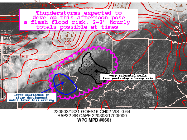
Summary...Thunderstorms are expected to develop later this
afternoon across central Illinois and possibly across eastern
Missouri. Intense rain rates up to 3"/hr are possible and the
flash flood threat will be increasing into the evening hours.

Discussion...Current visible imagery showed mostly clear skies
with temperatures soaring into the 80s across the outlook area.
With dewpoints in the mid to upper 70s, impressive instability has
developed over the region. The latest mesoanalysis showed upwards
of 3000 J/kg MLCAPE with a minimal amount of MLCIN in place. The
blended TPW product indicated precipitable water values were
between 1.5-1.7".

Convection is likely to develop mid to late afternoon across
central/north-central IL along a residual outflow boundary from
earlier convection to the north/northwest and ahead of the
approaching shortwave and pre frontal trough as the weak cap in
place erodes. The steeper mid level lapse rates should contribute
to robust, deep convection that quickly grows upscale. This
activity is then expected to develop/propagate south/southwest
toward south-central IL and eastern MO by late afternoon into
early evening.

The available hi-res guidance, including the recent runs of the
HRRR, show potential for hourly totals up to 3" at times due to
the extreme instability/moisture and potential for backbuilding.
Through 01Z, the potential exists for isolated 3-6" totals across
central/west-central IL. The 12Z HREF neighborhood probabilities
show even some isolated/very slight signals for 8" totals.

Parts of the outlook were hard hit with heavy rainfall yesterday
and as a result have more saturation and sensitivity to additional
rainfall. The recent NASA SPoRT soil moisture produce shows
portions of central IL top 40 cm layer with 80-90+ percent
saturation. If convection were to form over these regions, locally
significant flash flooding could occur.

Taylor

ATTN...WFO...DVN...ILX...IND...LOT...LSX...PAH...SGF...

ATTN...RFC...LMRFC...MBRFC...NCRFC...OHRFC...NWC...

LAT...LON   40978846 40788778 40388742 39868727 38698786
            37878949 37399080 37629164 38369203 39069199
            39949113 40509027 40888940
Last Updated: 229 PM EDT Wed Aug 03 2022
|


