| WPC Met Watch |
|
|
Mesoscale Precipitation Discussion: #0663 (2018) |
|
(Issued at 1214 AM EDT Wed Aug 15 2018
) |
|
| MPD Selection |
|
|
|
|
|

Mesoscale Precipitation Discussion 0663
NWS Weather Prediction Center College Park MD
1214 AM EDT Wed Aug 15 2018

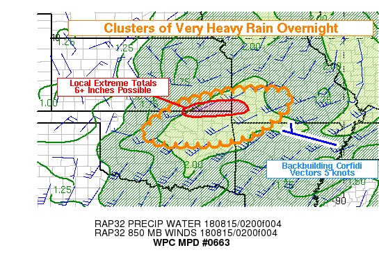
Areas affected...SE KS...NE OK...SW MO...NW AR

Concerning...Heavy rainfall...Flash flooding likely

Valid 150414Z - 150844Z

Summary...Conditions were ideal for training to produce locally
extreme rainfall amounts in southeast Kansas through 08Z. With
time, other clusters of heavy rain will develop toward parts of
northeast Oklahoma and nearby AR/MO.

Discussion...While synoptic lift at the base of a compact upper
low was favorable along the length of the low level jet,
convection had become organized in clusters owing to the influence
of outflows in Oklahoma. This had left a relatively concentrated
area of uninhibited and unstable inflow into a line of convection
taking shape over southeast Kansas at 04Z. With RAP Corfidi
vectors suggesting very little movement, and the 00Z NAM CONUS
Nest solution depicting 6-plus inches of rain, there is concern
that a near-term extreme rain event could be unfolding from
Chautauqua to Labette counties. RAP soundings depicted unstable
low level air in conjunction with deep layer 2.0 inch PW values.
With the event occurring below the melting layer as sampled from
KINX and KICT, dual-pol estimates of 3-plus inches per hour were
likely accurate.

Only the CONUS Nest really captured this event, and it holds onto
convection in SE KS through at least 08Z. This appears possible,
although the majority of guidance suggests at least some shift or
redevelopment toward the east over time and also down south were
the RAP places greater low level mass flux convergence into
eastern OK and western AR with time. Thus, additional clusters of
heavy rain and flash flooding are likely to form overnight.

Finally, convective overturning in central Oklahoma had not
entirely suppressed the environment, as new echoes had developed
from Kingfisher to Guthrie as of 04Z, sitting atop the cold pool
within an area of pronounced synoptic forcing / noting a dry punch
per GOES-16 water vapor imagery working down from the north. An
additional 1 to 2 inches of rain with this activity could lead to
new flash flooding in parts of central Oklahoma, and mid level
forcing is not forecast to really drop off until after 09Z.

Burke

ATTN...WFO...ICT...LZK...OUN...SGF...TSA...

ATTN...RFC...ABRFC...LMRFC...MBRFC...

LAT...LON   37779442 37669224 36329335 35789494 35749742
            36189818 36879732 37309655
Last Updated: 1214 AM EDT Wed Aug 15 2018
|


