| WPC Met Watch |
|
|
Mesoscale Precipitation Discussion: #0692 (2022) |
|
(Issued at 1255 PM EDT Sat Aug 06 2022
) |
|
| MPD Selection |
|
|
|
|
|

Mesoscale Precipitation Discussion 0692
NWS Weather Prediction Center College Park MD
1255 PM EDT Sat Aug 06 2022

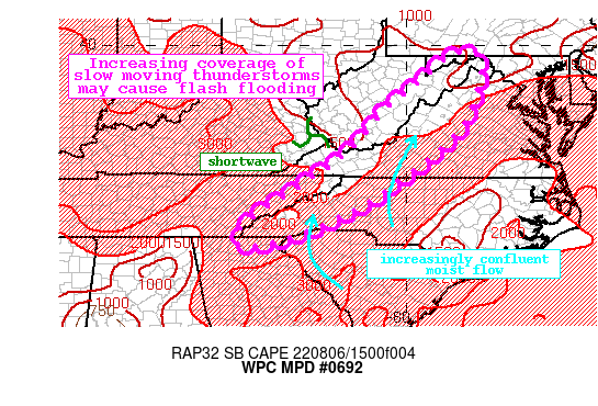
Areas affected...Southern and Central Appalachians

Concerning...Heavy rainfall...Flash flooding possible

Valid 061700Z - 062300Z

Summary...Slow moving showers and thunderstorms will continue to
develop across the Appalachians this aftn and evening. These
storms will be slow moving and contain rain rates of 1-2"/hr.
Flash flooding is possible.

Discussion...The GOES-E IR imagery this aftn in conjunction with
the regional radar mosaic indicates an expansion of showers and
thunderstorms from the southern terminus of the Appalachians
northward through the Panhandle of WV. These storms are developing
in an environment of extremely favorable thermodynamics
characterized by PWs of 1.7-2 inches, and collocated SBCAPE of
2000-3000 J/kg. A shortwave noted on WV imagery moving eastward
out of Kentucky is working in tandem with a weak mid-level trough
overhead to enhance ascent, while return flow around high pressure
centered over the Carolinas is converging into the terrain while
advecting higher moisture northward. Although convection is just
starting to intensify, radar estimated rain rates are already
1-1.5"/hr on local radars.

The presence of the trough aloft to steepen lapse rates combined
with weak height falls/PVA, upslope ascent, and robust instability
will fuel rapid development and expansion of convection through
the aftn. The high-res guidance is in good agreement that
convection will become widespread, generally across the higher
terrain, but maintain pulse-behavior as 0-6km shear remains 20 kts
or less. The elongated trough aloft and high pressure centered
near the Carolinas will keep overall flow weak, and storm motions
are progged to be just 5-10 kts from the SW across the area. At
the same time, as low-level flow veers more to the south, Corfidi
vectors are progged to become more opposed to the mean flow
suggesting an enhanced backbuilding or training threat, with
additional slow motion possible where terrain influences impact
storm initiation. These slow moving/training storms will likely
have rain rates of 1-2"/hr, which could produce 1-3" of rainfall,
with pockets of even higher amounts possible as reflected by the
HREF neighborhood probabilities.

24-hr rainfall according to MRMS has been 1-2" with pockets of
more than 3", adding to rainfall that has been as high as 200% of
normal the past 14 days. This has compromised FFG to as low as
1-1.5"/3hrs in the terrain, which the HREF indicates has a 40-60%
chance of being exceeded. Scattered instances of flash flooding
are possible through loss of heating, with the greatest risk
occurring where slow moving/training storms fall atop these
saturated soils in the more sensitive terrain.


Weiss

ATTN...WFO...CTP...FFC...GSP...LWX...MRX...PBZ...RLX...RNK...

ATTN...RFC...LMRFC...MARFC...OHRFC...SERFC...NWC...

LAT...LON   39807828 39537812 39117809 38117843 37317910
            36528011 35858110 35438199 35338214 34898338
            34778404 34828442 35208434 35558395 35788361
            36528246 37238147 38258061 38997972 39697890
Last Updated: 1255 PM EDT Sat Aug 06 2022
|


