| WPC Met Watch |
|
|
Mesoscale Precipitation Discussion: #0693 (2019) |
|
(Issued at 208 PM EDT Wed Jul 31 2019
) |
|
| MPD Selection |
|
|
|
|
|

Mesoscale Precipitation Discussion 0693
NWS Weather Prediction Center College Park MD
208 PM EDT Wed Jul 31 2019

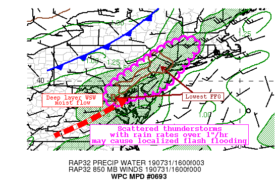
Areas affected...I-95 corridor from Washington D.C. to Connecticut

Concerning...Heavy rainfall...Flash flooding possible

Valid 311800Z - 010000Z

Summary...Scattered thunderstorms well ahead of a cold front may
train across areas with lowered flash flood guidance. Although
storms are expected to generally move quickly, training of echoes
with rain rates of 1-2"/hr may cause flash flooding. Urban areas
or locations which have received significant rainfall recently
will be most susceptible.

Discussion...A cold front was analyzed moving into western PA and
NY, while a pre-frontal trough was serving as focus for convective
development from near Washington D.C. through Southern New
England. The low-level convergence along this boundary was working
in tandem with modest upper diffluence within the broad RRQ of a
jet streak moving across SE Canada, as well as a weak
shortwave/MCV evident in satellite imagery across MD to induce
ascent.

The environment across the area will become increasingly favorable
for heavy rainfall into the early evening. PWATs, which were
analyzed at 12Z to be between 1.3 and 1.6 inches, should climb as
high as 1.75 inches or more on deep layer pre-frontal SW flow.
Additionally, in this warm sector instability is likely to
continue to rise, becoming around 3000 J/kg during peak heating.
The large scale ascent within this thermodynamic environment will
support rain rates of at least 1"/hr, with recent HREF
neighborhood probabilities indicating a 20-30% chance of 2"/hr
rain rates as well. Additionally, HREF probabilities indicate a
modest potential for 3" of rainfall, and despite the anticipated
scattered nature of thunderstorms, HRRR, ARW, and CONEST all
suggest pockets of more than 3" of rainfall due to convection.

The limiting factor to flash flooding is two-fold. First, the FFG
is moderately high noted by 3-hr FFG of 2.5-4" across most of the
area. The exception is in the low-permeability urban areas, as
well as portions of northern NJ and southeast NY where 14-day
rainfall has been 200-300% of normal despite very little rain in
the last 7 days. The other limiting factor will be modestly rapid
storm motion to the northeast, noted by 850-300mb cloud layer wind
of 20-25 kts, and RAP forecast 0-6km mean wind of 15-20 kts. This
suggests storms will move off to the northeast at a speed
generally too quick for flash flooding. However, Corfidi vectors
aligned to the mean flow and parallel to the pre-frontal trough
suggests training is possible, and if storms should train with
rain rates of 1-2"/hr, flash flooding will be possible anywhere
within the discussion area. If any storm should train over an
urban area or across the region with lowest FFG, flash flooding
could be more likely.

Weiss

ATTN...WFO...ALY...BGM...BOX...CTP...LWX...OKX...PHI...

ATTN...RFC...MARFC...NERFC...

LAT...LON   42317277 42307254 42057230 41837251 41587266
            41007311 40407359 39967397 39617447 39367499
            39227557 39097619 38927654 38747708 38827739
            39037759 39517743 40027694 40577617 41217529
            41857432 42287335
Last Updated: 208 PM EDT Wed Jul 31 2019
|


