| WPC Met Watch |
|
|
Mesoscale Precipitation Discussion: #0694 (2022) |
|
(Issued at 342 PM EDT Sat Aug 06 2022
) |
|
| MPD Selection |
|
|
|
|
|

Mesoscale Precipitation Discussion 0694
NWS Weather Prediction Center College Park MD
342 PM EDT Sat Aug 06 2022

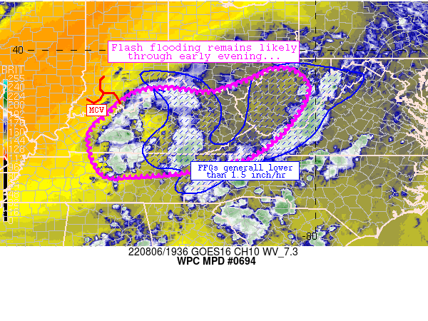
Areas affected...much of Kentucky, northern/northeastern Tennesee,
much of West Virginia, southwestern Virginia

Concerning...Heavy rainfall...Flash flooding likely

Valid 061940Z - 070140Z

Summary...Flash flooding remains likely across the discussion area
through the early evening as slow-moving storms traverse very wet
soils from prior rainfall.

Discussion...Slow-moving convection continues to rebuild and
traverse the discussion area currently.  The most recent
convective development has focused on the western flank of
rain-cooled air over central Kentucky, where abundant
heating/moisture and subtle low-level convergence both along
remnant boundaries and within the open warm sector exist.  Rain
rates continue to exceed 1 inch/hr in a few spots, which isn't
surprising given near 2-inch PW values and slow cell movement.  A
few low to moderate MRMS Flash responses are noted beneath the
stronger storms also.

Storms should continue to slowly move/propagate east-northeastward
through early evening.  Meanwhile, soil conditions are anomalously
moist from prior convection especially in Kentucky where FFG
thresholds are less than 1 inch/hr.  A few spots of lowered FFG
also exist in northeastern Tennessee and across West Virginia this
afternoon.  The aforementioned areas are most susceptible to flash
flooding this afternoon.

Additional, yet more isolated instances of flash flooding are
possible across middle Tennessee and vicinity.  Ground conditions
there are somewhat drier with less antecedent rainfall noted, and
rain rates would need to be higher to eclipse FFG thresholds.

Convection in all areas should be diurnally driven and lessen in
coverage and intensity early tonight (after 02Z or so).

Cook

ATTN...WFO...ILN...JKL...LMK...MRX...OHX...PAH...RLX...RNK...

ATTN...RFC...LMRFC...OHRFC...NWC...

LAT...LON   39348140 39278067 38658024 37478095 36548207
            36378270 36048412 35908588 35958698 37168739
            37888678 38588590 38718476 38588349 38998219
Last Updated: 342 PM EDT Sat Aug 06 2022
|


