| WPC Met Watch |
|
|
Mesoscale Precipitation Discussion: #0719 (2018) |
|
(Issued at 643 PM EDT Sun Aug 26 2018
) |
|
| MPD Selection |
|
|
|
|
|

Mesoscale Precipitation Discussion 0719
NWS Weather Prediction Center College Park MD
643 PM EDT Sun Aug 26 2018

Areas affected......Eastern North Dakota and northern Minnesota...

Concerning...Heavy rainfall...Flash flooding possible

Valid 262300Z - 270500Z

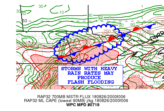
Summary...Thunderstorms developing in advance of an upper low and
near a front will produce heavy rains with local flash flooding
possible.

Discussion...The models show an upper level trough moving east
from MT into North Dakota this evening.  Mid level cyclonic
vorticity advection combines with low level convergence near a
stationary front
and mid level warm/moisture advection to generate increase shower
and thunderstorm coverage.

Layer surface to 6 km winds are forecast to be out of the
southwest, so east northeast motions are expected. The flow with
mixed layer CAPE values on 2-3 KJ/KG supports thunderstorm
development near the frontal boundary.

Storms that train in the vicinity of the boundary could lead to
rain rates of 1-2 inches per hours and localized totals of 2-4
inches, as shown in the 18z NAM Conus Nest and 20z High Res Rapid
refresh.  These amounts have the greatest chance of exceeding
flash flood guidance in eastern North Dakota and adjacent portions
of northern MN.  Further east in north central MN, flash flood
guidance values increase, making it more difficult to reach the
3-4 inch criteria.

The high res ARW/NMMB ensemble members and 18z Canadian regional
GEM are lighter on QPF than the 18z Conus Nest, reflecting
uncertainty as to the degrees of training anticipated.

Petersen

ATTN...WFO...DLH...FGF...

ATTN...RFC...NCRFC...

LAT...LON   49449319 49139252 48669208 48089197 47659272
            46829432 46519484 46339541 46289628 46409738
            46959820 47529800 47759791 48289722 48789617
            49179497
Last Updated: 643 PM EDT Sun Aug 26 2018
|


