| WPC Met Watch |
|
|
Mesoscale Precipitation Discussion: #0733 (2018) |
|
(Issued at 810 PM EDT Tue Aug 28 2018
) |
|
| MPD Selection |
|
|
|
|
|

Mesoscale Precipitation Discussion 0733
NWS Weather Prediction Center College Park MD
810 PM EDT Tue Aug 28 2018

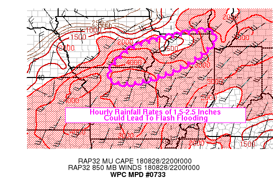
Areas affected...SW IA...NW IL...Extreme NE MO

Concerning...Heavy rainfall...Flash flooding possible

Valid 290009Z - 290609Z

Summary...Highly favorable thermodynamic environment will make for
a heightened short-term excessive rainfall threat associated with
the linear convection pushing through this evening.

Discussion...A well-organized QLCS was taking shape early this
evening along the western and northern periphery of the outlook
area, in a moisture-rich environment with anomalous PW values
around 2.0 inches. MUCAPES of 2500-4000 j/kg, along with the
favorable synoptic scale forcing ahead of an approaching upper
trough and surface front, are allowing for highly-efficient short
term rainfall rates in spite of the fairly progressive cell
motions.

The degree of bulk shear, along with the downdraft CAPE per the
latest SPC mesoanalysis will maintain the downwind propagation and
limit the potential for cell training -- at least until the
low-level boundary becomes more w-e oriented later this evening.
Nevertheless, the intense hourly rainfall rates of 1.5-2.5 inches
may lead to flash flooding given the current antecedent conditions
and FFG values. The bulk of the latest high-res CAM guidance in
fact shows pockets of 3-5 inches of rainfall within the outlook
area.

Hurley

ATTN...WFO...DMX...DVN...EAX...ILX...LOT...LSX...MKX...

ATTN...RFC...MBRFC...NCRFC...

LAT...LON   42618782 42108759 41528818 40778923 40159069
            39789205 39869334 40699323 41749194 42458921
Last Updated: 810 PM EDT Tue Aug 28 2018
|


