| WPC Met Watch |
|
|
Mesoscale Precipitation Discussion: #0736 (2020) |
|
(Issued at 1248 PM EDT Thu Sep 10 2020
) |
|
| MPD Selection |
|
|
|
|
|

Mesoscale Precipitation Discussion 0736
NWS Weather Prediction Center College Park MD
1248 PM EDT Thu Sep 10 2020

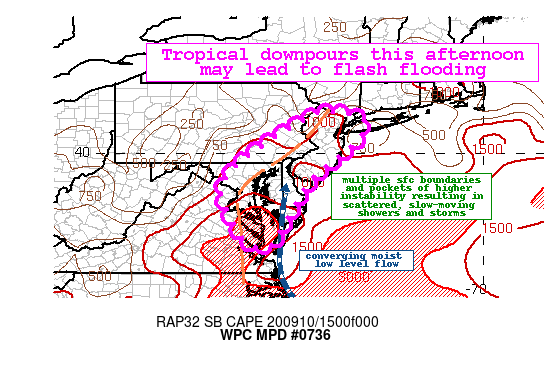
Areas affected...Mid-Atlantic to New Jersey and NYC area

Concerning...Heavy rainfall...Flash flooding possible

Valid 101648Z - 102248Z

Summary...Tropical moisture in place across the region will result
in heavy downpours at times through the afternoon. Hourly rain
totals up to 2" will be possible with localized 3-5" amounts. This
could lead to flash flooding, particularly over urban and other
sensitive areas.

Discussion...The surface trough associated with the tropical
moisture/wave that has been slowly moving inland today now is
draped along the I-95 corridor from near Richmond to DC/Baltimore
to west of Philadelphia. This is along an instability gradient and
differential heating boundary likely associated with early morning
convection that moved through portions of MD/DE/NJ/NY. With
instability now building into the 2000-2500 J/kg range from
daytime heating, deeper convection has developed per recent radar
imagery and cooling clouds seen in IR. The deep, anomalously high
tropical moisture remains in place with PWs as high as 2.3-2.5"
across portions of the region.

The latest hi-res guidance including the last few runs of the HRRR
are signaling for the highest rainfall this afternoon to fall
along the highly urban corridor from near DC to Baltimore to
central NJ. This is where the HREF prob for 5" is the highest
(20-50 perecent) and matches up well with a weak vort max that is
working through eastern VA right now. So the expectation is for a
blossoming of convection this afternoon that will be capable of
producing hourly totals up to 2" at times and generally will be
slow-moving (mean flow parallel to storm motions) or repeating in
places. Localized 3-5" totals will be possible given the
environment and storm motions. With the potential for this type of
rainfall over a highly urban corridor and other sensitive areas
including those with low FFG due to recent rainfall, some
localized flash flooding will be possible into the afternoon.

Taylor

ATTN...WFO...AKQ...CTP...LWX...OKX...PHI...

ATTN...RFC...MARFC...NERFC...NWC...

LAT...LON   41187446 40727333 39117503 37697584 37307620
            37587687 38887748 39817683 40817533
Last Updated: 1248 PM EDT Thu Sep 10 2020
|


