| WPC Met Watch |
|
|
Mesoscale Precipitation Discussion: #0737 (2021) |
|
(Issued at 906 PM EDT Sat Aug 07 2021
) |
|
| MPD Selection |
|
|
|
|
|

Mesoscale Precipitation Discussion 0737
NWS Weather Prediction Center College Park MD
906 PM EDT Sat Aug 07 2021

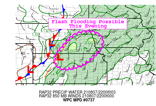
Areas affected...Northern Kansas...Southeast Nebraska

Concerning...Heavy rainfall...Flash flooding possible

Valid 080105Z - 080705Z

Summary...Deep, organized convection blossoming over portions of
the central Plains this evening may produce heavy rainfall and
localized flash flooding.

Discussion...Deeper convection is beginning to blossom along a
pre-frontal surface trough this evening with recent IR imagery
showing rapidly cooling cloud tops from portions of central Kansas
to far southern Nebraska. This activity is within a belt of higher
instability (2000-3000 J/kg MLCAPE) and gradually moving into the
deeper moisture present across the region. The expectation over
the next several hours for storms to move north/northeast and grow
upscale as the mid/upper level shortwave approaches. An increasing
low level jet with help foster more intense rain rates and the
latest HREF shows good support for hourly totals between 1-2" at
times. Storm motions oriented along the deep mean flow could lead
to some training or regeneration on the southern flanks of any
line segments, which seems to be happening based on the latest
radar and satellite imagery across southern Nebraska.

Much of the area has been running drier than normal and this could
limit the scope of the flash flooding. But the intense rain rates
and potential training could lead to localized instances of flash
flooding.

Taylor

ATTN...WFO...DDC...EAX...GID...ICT...OAX...TOP...

ATTN...RFC...ABRFC...MBRFC...NWC...

LAT...LON   42079682 41979586 41519519 40739526 40169564
            39049697 38579871 38939961 39869953 41629798
Last Updated: 906 PM EDT Sat Aug 07 2021
|


