| WPC Met Watch |
|
|
Mesoscale Precipitation Discussion: #0739 (2018) |
|
(Issued at 704 AM EDT Fri Aug 31 2018
) |
|
| MPD Selection |
|
|
|
|
|

Mesoscale Precipitation Discussion 0739
NWS Weather Prediction Center College Park MD
704 AM EDT Fri Aug 31 2018

Areas affected...Southern New Jersey...southeast
Pennsylvania...central to northern Maryland...Delaware

Concerning...Heavy rainfall...Flash flooding possible

Valid 311104Z - 311704Z

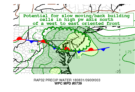
Summary...Slow moving and back building cells likely to the north
of a west to east frontal boundary stretching across the
Mid-Atlantic.  Flash flooding likely this morning into early
afternoon...especially for cells affecting urbanized areas.

Discussion...Early Friday morning surface analysis is showing a
well defined west to east front stretching across the Mid-Atlantic
from the panhandle of West Virginia...across central Maryland and
into southern Delaware.  PW values in the vicinity of this
boundary are expected to remain much above normal today...1.5+
standard deviations above the mean and mu-cape values are forecast
to increase into this afternoon...reaching 500-1000+ j/kg along
and north of the front.  Regional radars this morning already
showing scattered convection forming in this high pw axis to the
north of the front..much of which is slow moving.   The activity
across the eastern portion of the risk area is showing back
building over central to southern New Jersey...where rainfall
rates of 2-3" per hour and totals of 5"+ have already been
observed near Mount Holly, NJ.  While the simulated radars from
the 0000 UTC hi res guidance...arw...nmmb and arw2...are not
depicting the current activity well...showing typical bias of
being too slow to form and underdone in areal coverage...they all
do show potential for convection to continue to the north of this
front through this morning and into this afternoon. Hi res model
consensus is for the greatest heavy rain threat over southeast
PA...southern NJ...northeast MD and Delaware over the next 6
hours.  However...with the above mentioned poor handling of
current convection in the hi res guidance...the risk area was
drawn larger to encompass a broader region along and to the north
of the stationary front.  With the potential for slow moving and
back building of cells..hi pw values..increasing instability and
warm rain processes...additional areas of very heavy rains...2-3"+
per hour likely to the north of this front through this morning
and into this afternoon.

Oravec

ATTN...WFO...BGM...CTP...LWX...PHI...

ATTN...RFC...MARFC...OHRFC...

LAT...LON   40987655 40797529 40367429 40157391 39677351
            39417350 38907409 38737467 38737591 39017722
            39467817 39617832 40337871 40957845
Last Updated: 704 AM EDT Fri Aug 31 2018
|


