| WPC Met Watch |
|
|
Mesoscale Precipitation Discussion: #0741 (2018) |
|
(Issued at 227 AM EDT Sat Sep 01 2018
) |
|
| MPD Selection |
|
|
|
|
|

Mesoscale Precipitation Discussion 0741
NWS Weather Prediction Center College Park MD
227 AM EDT Sat Sep 01 2018

Areas affected...Far northern MO, southern and eastern IA,
west-central and northwest IL, southwest WI

Concerning...Heavy rainfall...Flash flooding possible

Valid 010625Z - 011225Z

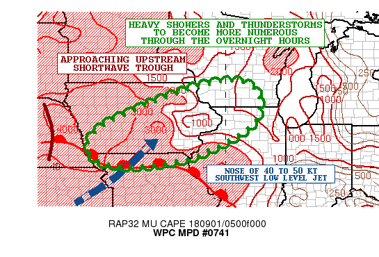
Summary...Heavy showers and thunderstorms will be expanding in
coverage and organization through the overnight hours. Some flash
flooding will be possible as rainfall rates increase.

Discussion...A strong warm advection pattern ahead of a shortwave
trough ejecting out across the central Plains will be facilitating
the expansion of heavy showers and thunderstorms across portions
of the Midwest through the overnight hours and going through dawn.

Already there has been the development of multiple clusters of
cold-topped convection in an elevated fashion across areas of
southwest to central IA and also far northern MO in association
with the nose of a moist 40 to 50 kt southwest low level jet that
is overrunning a warm front lifting northeast across the Midwest.

The convection is embedded within a strong instability gradient
aloft characterized by MUCAPE values of 2000 to 3000 j/kg.
However, there is actually even stronger instability pooled
farther back to the west over eastern NE where MUCAPE values of as
much as 4000 j/kg are noted. This degree of very strong elevated
instability and forcing supported by the low level jet and arrival
of mid level DPVA associated with the shortwave should allow
convection to expand and organize further in coverage over the
next several hours. Much of far northern MO, and southern and
eastern IA will see the main convective potential over the next 2
to 3 hours, but gradually areas of northwest IL and southwest WI
toward dawn will see convection arrive as the upstream energy
approaches from the southwest.

The 00Z HREF model suite all favor heavy rainfall totals through
12Z with as much as 3 to 5 inches of rain. The HRRR guidance has
been a bit more conservative with its coverage, but also locally
supports these amounts. Given the multiple rounds of convection
that will likely be seen, and the moist environment with PWATs of
1.6 to 1.8 inches, these amounts seem reasonable but with coverage
more consistent with that of the HREF mean.

Given the expected rainfall totals and heavy short-term rates
approaching 2 inches/hr, some flash flooding will be possible
going through the early morning hours.

Orrison

ATTN...WFO...ARX...DMX...DVN...EAX...ILX...LOT...LSX...MKX...
OAX...

ATTN...RFC...MBRFC...NCRFC...

LAT...LON   43529014 43438915 42908863 41958876 41238970
            40529117 40249223 40069381 40209505 40539547
            40969567 41659507 42349369 43119173
Last Updated: 227 AM EDT Sat Sep 01 2018
|


