| WPC Met Watch |
|
|
Mesoscale Precipitation Discussion: #0744 (2020) |
|
(Issued at 649 PM EDT Sat Sep 12 2020
) |
|
| MPD Selection |
|
|
|
|
|

Mesoscale Precipitation Discussion 0744
NWS Weather Prediction Center College Park MD
649 PM EDT Sat Sep 12 2020

Areas affected...FL Keys into southern FL

Concerning...Heavy rainfall...Flash flooding possible

Valid 122248Z - 130430Z

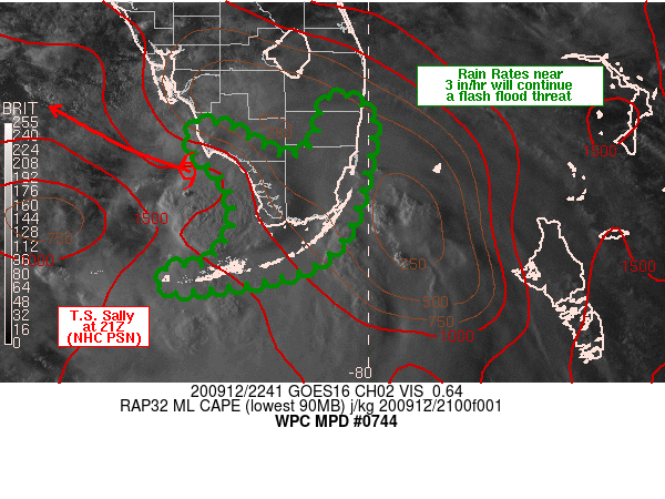
Summary...Torrential rainfall rates will remain possible over the
FL Keys into the southern Peninsula over the next several hours.
Peak rainfall rates near 3 in/hr can be expected with potential
for rapid rise inundation flooding.

Discussion...The 21Z advisory from NHC placed T.S. Sally roughly
30 miles SSW of Naples with a forecast movement off toward the
WNW. Regional radar reflectivity and visible satellite imagery
indicated low level confluent flow leading to narrow axes of
heavier rainfall located within the southeast quadrant of Sally.
One of these axes was located to the southeast of Biscayne Bay at
22Z, oriented from SSE to NNW, parallel to the deeper layer mean
flow.

Layered PW imagery showed deep layered moisture remained over the
region with the westward moving leading edge of "drier" air in the
upper levels 75 to 100 miles east of the southeast coast of the FL
Peninsula. The tropical moisture has been responsible for
widespread rainfall totals of 3-6 inches over the FL Keys with
localized totals in excess of 10 inches in portions of Islamorada.
Reports of rainfall from earlier this afternoon showed nearly 2
inches of rain in a 30 minute period over portions of Key West,
owing to the potential of the tropical environment.

A relative minimum in instability was estimated to be located over
southeastern FL at 22Z, according to the RAP and SPC mesoanalysis.
As Sally continues off toward the west, MLCAPE is expected to
increase across the southeastern coast early tonight, supporting
the potential for a low level inflow band to impact locations from
Palm Beach down to Miami-Dade counties. The beginning of this band
may already be forming offshore in the latest radar imagery. Low
level confluence may also support the formation of inflow bands
with heavy rain from the Keys into southwestern FL although
present trends in KBYX imagery and the forecast movement of Sally
suggests the heaviest rain would stay south of Naples. Farther
south along the Keys, additional heavy rain may lead to additional
rapid inundation flooding with continued threats for rain rates
near 3 in/hr through 04Z.

Otto

ATTN...WFO...KEY...MFL...

ATTN...RFC...SERFC...NWC...

LAT...LON   26508033 26438013 26247996 25778002 25118020
            24708059 24558109 24478166 24438202 24518219
            24628217 24698202 24698175 24768166 24838157
            24978147 25098142 25268141 25428143 25588150
            25678155 25758166 25848177 25968187 26068189
            26178184 26238173 26188160 26178148 25948110
            25858091 25868070 25978059 26128051 26268050
            26418045
Last Updated: 649 PM EDT Sat Sep 12 2020
|


