| WPC Met Watch |
|
|
Mesoscale Precipitation Discussion: #0745 (2023) |
|
(Issued at 944 AM EDT Sun Jul 16 2023
) |
|
| MPD Selection |
|
|
|
|
|

Mesoscale Precipitation Discussion 0745
NWS Weather Prediction Center College Park MD
944 AM EDT Sun Jul 16 2023

Areas affected...New England

Concerning...Heavy rainfall...Flash flooding likely

Valid 161343Z - 161943Z

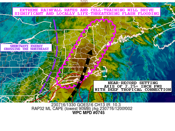
SUMMARY...Areas of significant and locally life-threatening flash
flooding are expected going through the early to mid-afternoon
hours from extremely heavy showers and thunderstorms.

DISCUSSION...The latest GOES-16 IR satellite imagery in
conjunction with dual-pol radar shows an expansive area of
extremely heavy shower and thunderstorm activity lifting north up
across central and southern New England as shortwave energy pivots
across the region ahead of a stronger upper trough gradually
dropping southeast into the Great Lakes region.

This energy is interacting with a plume of deep tropical moisture
and instability surging up along the East Coast and inland across
the Northeast. In fact, the latest 12Z RAOB data and VWP data
shows the nose of confluent 40+ kt low-level jet nosing in off the
western Atlantic Ocean and up across Long Island and much of the
interior of New England which is helping to drive a 2.25+ inch PW
axis up across CT/MA and nosing into southern NH and southwest ME.
These PWs are near or at record levels relative to climatology for
this time of the year.

Coinciding this corridor of strong moisture transport is an axis
of moderately unstable air with MLCAPE values of as much as 1000
to 1500 J/kg. Vertical shear parameters are relatively steep as
well with as much as 30 to 40 kts of effective bulk shear in place
which is facilitating some notably strong and linear bands of
convection with some transient supercell type structures.

Going through midday and the early to mid-afternoon time frame,
the heaviest rainfall focus is expected to be over CT/MA and a
large portion of NH and southwest ME where the stronger convective
cells will be capable of producing rainfall rates of 2 to 4
inches/hour, with additional rainfall totals of as much as 5 to 7
inches possible given notable concerns for cell-training. The
stronger orographic ascent/upslope flow into higher terrain of the
Worcester Hills of central MA and up into the White Mountains of
NH will be areas most likely to see the heaviest totals.

Given the combination of extreme rainfall rates, cell-training,
locally wet antecedent conditions and areas of rugged terrain,
there is an elevated threat of significant and life-threatening
flash flooding over the next several hours.

Orrison

ATTN...WFO...ALY...BOX...BTV...CAR...GYX...OKX...

ATTN...RFC...NERFC...NWC...

LAT...LON   45687070 45636982 45166939 44256964 43387020
            42177090 40847223 40497303 40727382 41567368
            42527302 44147211 45177139
Last Updated: 944 AM EDT Sun Jul 16 2023
|


