| WPC Met Watch |
|
|
Mesoscale Precipitation Discussion: #0757 (2020) |
|
(Issued at 218 AM EDT Tue Sep 15 2020
) |
|
| MPD Selection |
|
|
|
|
|

Mesoscale Precipitation Discussion 0757
NWS Weather Prediction Center College Park MD
218 AM EDT Tue Sep 15 2020

Areas affected...Central Gulf Coast from Mobile Bay, AL to
Apalachee Bay, FL

Concerning...Heavy rainfall...Flash flooding possible

Valid 150630Z - 151230Z

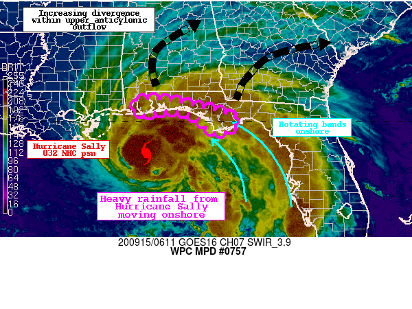
Summary...Heavy rainfall within the CDO of Hurricane Sally, as
well as rotating outer rain bands, will repeatedly move onshore
the western Florida Panhandle and southern Alabama coastline.
Rainfall rates will gradually begin to increase, likely exceeding
2"/hr at times later this morning. As these bands train onshore,
they could produce 1-3" of rainfall with locally higher amounts.
Flash flooding is possible.

Discussion...Hurricane Sally about 115 miles SE of Biloxi, MS is
moving slowly WNW this morning. The center of Sally is evident
from KMOB radar, and via GOES-E IR imagery where cloud top cooling
is periodically occurring. To the north and northeast of the
center, heavy rainfall within both the central dense overcast
(CDO) and associated with outer rain bands is occurring, and
lifting onshore the immediate Gulf Coast. While rain rates have
generally been less than 0.5"/hr according to mesonet
observations, radar estimates and the most recent AMSU pass
suggest offshore rain rates are as high as 3"/hr. These rates will
gradually begin to lift onshore through morning.

The environment around Sally is extremely favorable for heavy
rainfall. GPS observations indicate PWs of 2.25-2.50" advecting
onshore, and 00Z U/A soundings measured warm cloud depths
approaching 15,000 ft in an environment of tall skinny CAPE
supporting efficient warm rain coalescence processes. While
instability offshore is analyzed by the RAP to be greater than
2000 J/kg, MUCape along the coast is only around 500 J/kg. This
instability gradient is causing rain rates to weaken as they shift
onshore. However, moisture/instability transport on increasing
850mb winds which are measured by local VWPs to be 30-40 kts will
slowly drive MUCape upward along the coast. This combined with
increasing ascent through intensifying upper divergence and forced
low-level convergence where the 850mb wind exceeds the 850-300mb
mean wind should allow the heavy rain to expand northward through
the morning, and the HREF hourly probabilities indicate increasing
potential for rain rates exceeding 2"/hr after sunrise.

While rainfall may take a few more hours to materialize to truly
reach excessive rates, continuous moderate to at times heavy
rainfall will occur within the CDO and training convective bands
N/NE of the center of Sally. Rainfall in the last 24 hours has
exceeded 3" across parts of the western FL Panhandle, leading to
pre-conditioned soils which the NWM indicates have more than 85%
40-cm soil saturation. The likelihood of intensifying rain rates
training from east to west will produce 1-3" of rainfall with
locally higher amounts through 12Z as shown by most available
CAMs, with the heaviest rainfall likely along the immediate coast
where better instability resides and some frictional enhancement
may occur. Should this heavy rain occur atop these pre-saturated
soils, or across any urban areas, flash flooding will be possible.

Additional heavy rain, likely more significant than what is
expected this morning, will follow across these same areas through
Tuesday. Subsequent MPDs will continue to update the evolving
threat through the event.


Weiss

ATTN...WFO...MOB...TAE...

ATTN...RFC...SERFC...NWC...

LAT...LON   30748736 30728680 30578623 30408542 30318506
            30168469 30078451 29978445 29908456 29768471
            29648490 29608526 29688551 29948570 30148593
            30278627 30358673 30358702 30308724 30258749
            30218769 30218784 30268794 30438802 30708793
Last Updated: 218 AM EDT Tue Sep 15 2020
|


