| WPC Met Watch |
|
|
Mesoscale Precipitation Discussion: #0763 (2023) |
|
(Issued at 146 PM EDT Wed Jul 19 2023
) |
|
| MPD Selection |
|
|
|
|
|

Mesoscale Precipitation Discussion 0763
NWS Weather Prediction Center College Park MD
146 PM EDT Wed Jul 19 2023

Areas affected...Southeast MO, southern IL, western KY, western TN

Concerning...Heavy rainfall...Flash flooding possible

Valid 191744Z - 192200Z

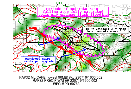
Summary...Periods of moderate rain will continue through the
afternoon atop extremely saturated soils. Additional rainfall of
1-2" with locally higher amounts is possible. This may lead to
renewed or exacerbated flash flooding.

Discussion...The GOES-E visible imagery this aftn depicts
expansive cloud cover in the vicinity of this mornings persistent
MCS from central MO through eastern KY and eastern TN. Within this
cloud cover, some bands of deeper Cu are developing along
outflows, differential heating boundaries, and through isentropic
upglide along a warm front analyzed by WPC to the southwest. While
the overall intensity of convection has waned due to
overturning/exhaustion of the instability, these convergent
boundaries are driving renewed lightning, especially upstream into
Missouri. The 850mb inflow according to the SPC RAP remains from
the WSW at 20-30 kts, resupplying more favorable thermodynamics
characterized by PWs of 1.8-2.0 inches and MLCAPE of 2000-3000
J/kg northward.

The high-res guidance differs in evolution during the next few
hours, producing somewhat lowered confidence in the evolution
through this evening. However, thunderstorms building across
Missouri along linear convergent boundaries will likely train to
the E/SE on mean 0-6km winds of 20-25 kts. These storms will move
southeast parallel to the front, with additional development
occurring upstream to suggest at least short term training of rain
rates that may reach 1"/hr. While current instability across KY/TN
is generally exhausted noted by MLCAPE of just 250-500 J/kg, the
resupply of the thermodynamics from the SW may allow this to
re-destabilize quickly as the cloud cover erodes. This will allow
storms to better maintain intensity as they train to the southeast
this aftn and into the evening, resulting in additional rainfall
of 1-2" with locally higher amounts.

This rainfall in itself does not generally appear sufficient for
flash flooding. However, 12-hr rainfall from this morning has been
widespread of 3-7" with locally more than 10" in some areas. This
has resulted in fully saturated soils noted by the HRRR soil
saturation percent, anomalous USGS streamflows, FFG as low as
0.25-0.5"/1hr, and ongoing flash flooding. Any additional moderate
rainfall on top of these soils could result in renewed or
exacerbated flash flooding.


Weiss

ATTN...WFO...HUN...LMK...LSX...MEG...MRX...OHX...PAH...SGF...

ATTN...RFC...LMRFC...MBRFC...NCRFC...OHRFC...NWC...

LAT...LON   38369155 38369042 38178958 37588805 36458629
            35788567 35308556 35088644 35108746 35388834
            35978927 36739034 37269164 37419226 37589249
            37919239
Last Updated: 146 PM EDT Wed Jul 19 2023
|


