| WPC Met Watch |
|
|
Mesoscale Precipitation Discussion: #0778 (2023) |
|
(Issued at 525 AM EDT Fri Jul 21 2023
) |
|
| MPD Selection |
|
|
|
|
|

Mesoscale Precipitation Discussion 0778
NWS Weather Prediction Center College Park MD
525 AM EDT Fri Jul 21 2023

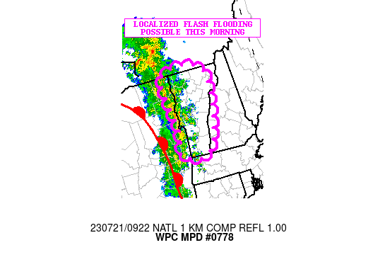
Areas affected...Much of Vermont

Concerning...Heavy rainfall...Flash flooding possible

Valid 210925Z - 211325Z

SUMMARY...Heavy showers and a few thunderstorms early this morning
will pose at least some localized concerns for flash flooding.

DISCUSSION...The latest radar imagery shows a broken axis of heavy
showers and a few thunderstorms crossing areas of far eastern NY
and into VT as a strong shortwave trough amplifies across the
Lower Great Lakes. This energy coupled with the advancement of a
warm front across the region will maintain a threat of convection
through at least the early morning hours.

Some of the rainfall rates may locally reach up to 1 inch/hour
with the stronger cells, and the latest radar trends suggest at
least enough repeating cell activity such that some storm totals
by mid-morning may reach 1.5 to 2.5 inches.

Given the lower FFG values across the region and elevated
streamflows from the very heavy rainfall over the last couple of
weeks, the additional rains early this morning may result in some
localized areas of flash flooding.

Orrison

ATTN...WFO...ALY...BOX...BTV...GYX...

ATTN...RFC...NERFC...NWC...

LAT...LON   45177263 44947203 44437196 43347224 42817257
            42667306 42827351 42937362 43487344 44037354
            44997360
Last Updated: 525 AM EDT Fri Jul 21 2023
|


