| WPC Met Watch |
|
|
Mesoscale Precipitation Discussion: #0806 (2024) |
|
(Issued at 832 PM EDT Sun Aug 04 2024
) |
|
| MPD Selection |
|
|
|
|
|

Mesoscale Precipitation Discussion 0806
NWS Weather Prediction Center College Park MD
832 PM EDT Sun Aug 04 2024

Areas affected...Western FL Peninsula through Northern FL
including the Big Bend

Concerning...Heavy rainfall...Flash flooding likely

Valid 050030Z - 050630Z

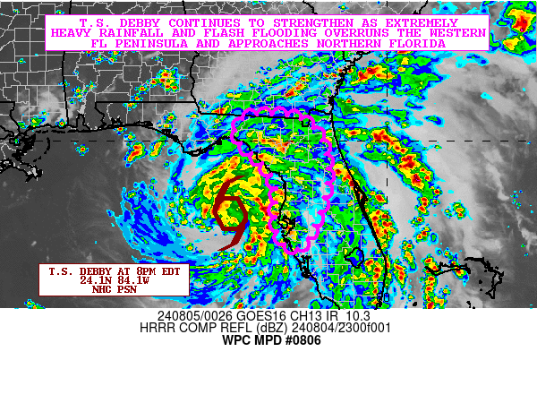
SUMMARY...Tropical Storm Debby continues to strengthen and should
become a hurricane later this evening as it gradually approaches
the Big Bend of FL. Meanwhile, very heavy rainfall bands continue
to impact the western FL Peninsula while spreading farther north
toward adjacent areas of northern FL. Flash flooding will continue
to be likely heading into the overnight hours with locally
severe/considerable urban flash flooding impacts.

DISCUSSION...As of 8PM EDT, Tropical Storm Debby was centered near
28.1N 84.1W, or about 90 miles southwest of Cedar Key, FL. The
storm is moving to the north at 12 mph. The late-day GOES-E IR
satellite imagery continues to show improving convective
organization with the storm as very cold convective cloud tops
(-75 to -80 C) continue to become concentrated around the center.
Coinciding with this is a rather well-defined and closed eyewall
signature seen in the KTBW dual-pol radar.

Meanwhile, impressive convective bands with very cold cloud tops
and extremely heavy rainfall rates continue around the eastern
semicircle of Debby's circulation with significant impacts ongoing
across portions of the western FL Peninsula. Some areas from
Sarasota northward through Tampa and Tarpon Springs have already
seen 4 to 8 inches of rain.

Additional very heavy rainfall will continue to impact portions of
the western FL Peninsula with heavy convective rains also becoming
more focused with time farther north across the Big Bend of Fl and
adjacent areas of northern FL. A moderately buoyant airmass with
MLCAPE values near 1500 J/kg coupled with strengthening low to
mid-level moisture flux convergence and low-level shear will favor
organized convective bands capable of producing rainfall rates of
2 to 3 inches/hour.

This coupled with notable cell-training concerns will support
additional rainfall amounts associated with Debby reaching 3 to 6
inches going through 2AM EDT. This accounts for the latest radar
and satellite trends which suggest Debby may be tracking just a
tad to the right of the earlier forecast heading, and thus
yielding somewhat heavier rainfall potential for the near-term
across the western FL Peninsula and into the Big Bend of FL.

Areas of flash flooding will continue in association with Debby,
and locally severe/considerable urban flash flooding impacts are
expected.

Orrison

ATTN...WFO...JAX...MLB...TAE...TBW...

ATTN...RFC...SERFC...NWC...

LAT...LON   30688287 30398200 29648161 28658162 27798191
            27208228 27268265 27868291 28688286 29358318
            30078390 30548379
Download in GIS format: Shapefile
| KML
Last Updated: 832 PM EDT Sun Aug 04 2024
|


