| WPC Met Watch |
|
|
Mesoscale Precipitation Discussion: #0817 (2020) |
|
(Issued at 500 AM EDT Sat Oct 10 2020
) |
|
| MPD Selection |
|
|
|
|
|

Mesoscale Precipitation Discussion 0817
NWS Weather Prediction Center College Park MD
500 AM EDT Sat Oct 10 2020

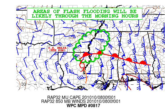
Areas affected...Northeast LA...Southeast AR...Central/Northern MS

Concerning...Heavy rainfall...Flash flooding likely

Valid 100900Z - 101500Z

SUMMARY...Delta continues to weaken, but will still be producing
heavy rain and areas of flash flooding going through the morning
hours.

DISCUSSION...As of 09Z (4AM CDT), Tropical Storm Delta was located
about 45 miles south-southeast of Monroe, LA with the storm
continuing to steadily weaken as it lifts north-northeast through
the lower MS Valley.

The radar depiction of Delta continues to deteriorate with the
heaviest rain confined to an area northeast of the center over far
northeast LA and west-central MS where some very cold convective
tops have blossomed over the last couple of hours. In fact, MRMS
data show some isolated 1.5 inch/hr rainfall rates occurring
within this cluster of stronger convection. However, the rest of
the precipitation shield associated with Delta is much less
impressive.

Moderate to heavy stratiform rain is occurring over a large area
of southeast AR to the north of Delta where strong warm-air
advection and moisture transport is seen advancing over a warm
front which is fostering robust isentropic ascent. Meanwhile,
farther to the east, strong southerly flow around Delta's eastern
flank is allowing for a nose of at least modest instability (500
to 1000 j/kg of MUCAPE) to lift up across southern/central MS and
this is also interacting with the same aforementioned warm front
and is fostering several bands and clusters of heavy showers and
thunderstorms which are rapidly lifting up through areas of
northern MS.

Going through the morning hours, T.S. Delta will continue to
steadily weaken and should be characterized by a large area of
moderate to heavy stratiform rain north and northwest of the low
track, with several bands of convection around its northeast and
eastern flanks where strong southerly flow will continue to favor
enhanced moisture convergence. The instability parameters though
are not forecast to be particularly impressive though, and this
will cut down on the rainfall rates.

The latest HRRR guidance suggests some of the rainfall rates
continuing to reach as high as 1.5 inches/hr with some of the
remaining convective elements ahead of Delta, with additional
rainfall totals going through 15Z (10AM CDT) of 2 to 5 inches.
Generally the heavier totals should be focused along the border
areas of southeast AR and northwest MS, along with far northeast
LA. Areas of flash flooding will be likely as a result with the
additional rainfall this morning.

Orrison

ATTN...WFO...JAN...LZK...MEG...SHV...

ATTN...RFC...LMRFC...NWC...

LAT...LON   34969021 34898954 34468936 33638976 32839025
            32329085 32319184 32729243 33339237 34459158
            34839092
Last Updated: 506 AM EDT Sat Oct 10 2020
|


