| WPC Met Watch |
|
|
Mesoscale Precipitation Discussion: #0828 (2019) |
|
(Issued at 1047 PM EDT Wed Sep 04 2019
) |
|
| MPD Selection |
|
|
|
|
|

Mesoscale Precipitation Discussion 0828
NWS Weather Prediction Center College Park MD
1047 PM EDT Wed Sep 04 2019

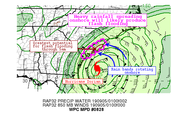
Areas affected...Coastal South Carolina

Concerning...Heavy rainfall...Flash flooding likely

Valid 050245Z - 050845Z

Summary...Heavy rainfall associated with the central dense
overcast of Hurricane Dorian will begin to spread inland across
coastal South Carolina. As Dorian lifts slowly northward, rainfall
rates will intensify, and may reach 3"/hr at times. Training of
these echoes will produce rounds of very heavy rainfall, which may
accumulate to 5" in some places. Flash flooding will become
increasingly likely overnight.

Discussion...The eye of Hurricane Dorian is clearly evident on
KCLX WSR-88D reflectivity about 130 miles south of Charleston, SC.
While the eye is SE of the South Carolina coast, heavy rainfall
embedded within outer rain bands and the Central Dense Overcast
(CDO) are lifting onshore. Recent estimated rain rates from KCLX
have been generally less than 1"/hr onshore, but much heavier
rainfall is lurking just to the east as noted by estimated rain
rates to 2"/hr approaching the coast.

These heavier rain rates are likely to spread inland over the next
few hours, leading to a rapidly increasing flash flood threat.
PWATs on the 00Z area soundings were generally 2.1-2.3", and the
blended TPW product suggests PWATs nearing 2.75" just offshore. As
Dorian approaches and low-level flow remains from the east, these
higher PWATs should advect onshore, which combined with increasing
MLCape to 1000 J/kg on WAA and rising warm cloud depths to above
15,000 ft will lead to improving rainfall efficiency as warm rain
cloud collision/coalescence processes dominate. This is suggested
as well by HREF neighborhood probabilities rising to above 30% for
2"/hr, with low probabilities also developing for 3"/hr. FFG is
generally high in this area, 2-3"/1hr and 2.5-4"/3hrs, but
preconditioning from moderate rain this evening has likely lowered
these values.

As ascent intensifies within the diffluent anticyclone atop Dorian
and 850mb wind speeds featuring even greater positive departures
from the 0-6km mean wind, heavy rain is likely to spread further
inland. However, the heaviest rainfall is expected to remain near
the coast as forced ascent is greatest due to stronger low-level
inflow,frictional convergence, and greater temporal duration of
the excessive rain rates due to closer proximity to the CDO of
Dorian. There is very good CAM consensus that 1-3" of rainfall
will occur across coastal portions of SC by early morning, with
isolated amounts to 5" likely. This is also supported by recent
WoFS output which depicts a 90% chance for 2" of rainfall, and
even some low probabilities for 5".

Flash flooding is expected to gradually become more likely
overnight, but should be focused along the coastal urban areas or
where training of the 2-3"/hr rain rates occurs.

Weiss

ATTN...WFO...CHS...ILM...

ATTN...RFC...SERFC...

LAT...LON   33647923 33637913 33607898 33317909 33097931
            32907970 32668002 32508029 32348048 32148071
            32058087 32118105 32258109 32698077 33028027
            33297993 33627944 33617949
Last Updated: 1047 PM EDT Wed Sep 04 2019
|


