| WPC Met Watch |
|
|
Mesoscale Precipitation Discussion: #0832 (2018) |
|
(Issued at 1137 PM EDT Thu Sep 13 2018
) |
|
| MPD Selection |
|
|
|
|
|

Mesoscale Precipitation Discussion 0832
NWS Weather Prediction Center College Park MD
1137 PM EDT Thu Sep 13 2018

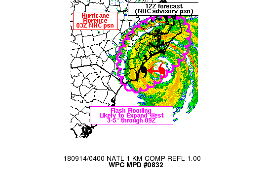
Areas affected...eastern NC

Concerning...Heavy rainfall...Flash flooding likely

Valid 140336Z - 140900Z

Summary...3-5 inches of rain is expected over the central to
southern NC Coastal Plain by 09Z. Repeating rounds of 1-2 in/hr
rain rates (occasionally higher) and flash flooding are likely.

Discussion...At 03Z, Hurricane Florence was located about 65 miles
east of Wilmington, NC, and continued to move slowly west at 5
mph. Observed rainfall rates within Florence's spiral bands that
were impacting coastal locations between Cape Lookout and Cape
Fear have been roughly 1-2 in/hr since 00Z, which is near or a bit
below KTLX dual-pol estimates. GOES 16 10.3 micron infrared
imagery has been relatively steady state over the past 2-3 hours
with periodic bursts of colder cloud tops, followed by
warming/fading. One such cold burst had been observed just south
of the Crystal Coast between 0245z and 0315Z, tied to the northern
eyewall of Florence. Precipitable water values continue to rise as
the center of Florence nears the coast with the 00Z RAOB from MHX
showing 2.64 inches (0.31 inches higher than 18Z) and a wet bulb
zero height of 16.3 kft which certainly correlates to ongoing warm
rain processes.

As Florence continues a slow westward movement, spiral bands will
continue to enhance and weaken as they slowly translate inland
across eastern portions of NC, capable of 1-2+ in/hr rain rates
atop increasing soil moisture. Farther north, the potential exists
for east to west training within spiral bands on the north side of
Florence from near Cape Hatteras to just east of I-95. The 03Z NHC
advisory for Florence will take the northwestern edges of the
eyewall toward North Topsail and Topsail beach by 09Z including
rainfall rates in excess of 2 in/hr. The slow movement of Florence
and the heavy tropical rainfall will continue the flash flooding
threat through 09Z.

Otto

ATTN...WFO...AKQ...ILM...MHX...RAH...

ATTN...RFC...SERFC...

LAT...LON   35957634 35847572 35607533 35187526 34427566
            34337584 33747712 33547811 33907855 34687854
            35347809 35797732
Last Updated: 1137 PM EDT Thu Sep 13 2018
|


