| WPC Met Watch |
|
|
Mesoscale Precipitation Discussion: #0860 (2018) |
|
(Issued at 152 AM EDT Tue Sep 18 2018
) |
|
| MPD Selection |
|
|
|
|
|

Mesoscale Precipitation Discussion 0860
NWS Weather Prediction Center College Park MD
152 AM EDT Tue Sep 18 2018

Areas affected...upstate NY into southern New England

Concerning...Heavy rainfall...Flash flooding possible

Valid 180552Z - 181150Z

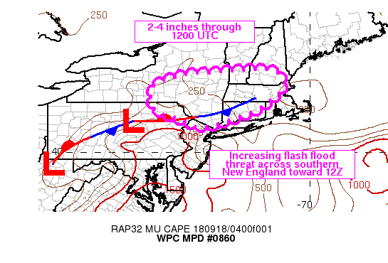
SUMMARY...Steady light to moderate rain with embedded heavy cores
on the local level should continue across upstate New York into
southern New England. The threat for heavier rain rates and
possible flash flooding will increase toward sunrise across
southern New England.

DISCUSSION...Regional radar imagery at 05Z showed a broad area of
rainfall extending from the PA/NY border into and across upstate
NY into portions of southern New England. A meso-low was also
noted at the western edge of the precipitation shield along the
central PA/NY border, with the heaviest rainfall rates just ahead
across Chemung and Tioga counties with surface observations
showing between 0.5 and 1.0 in/hr, above KBGM estimates perhaps
owing to the small, near spherical droplet sizes evidenced by low
differential reflectivity values ranging between 0.8 and 1.3 db.
The rainfall was occurring north of a stationary front where
MUCAPE was generally less than 500 J/kg, with the boundary
separating higher dewpoints to the south.

Low level moisture transport will increase across eastern NY into
New England through 12Z, out ahead of a low-mid level trough
moving across the region. The influx of higher moisture in the low
levels should increase MUCAPE values over southern upstate NY and
southern New England into the 500-1000 J/kg range by 12Z as seen
in a consensus of the 00Z hi-res guidance and recent runs of the
RAP. Weaker instability across northern locations of central NY
into northern MA, southern VT and southern NH should temper
rainfall rates with steady 0.5 to 1.0 in/hr rates at times
allowing rainfall to accumulate into the 2-4 inch range for a few
spots. Farther south, coverage of rainfall is expected to be less
than northern locations but greater instability is expected to
support higher rain rates, in excess of 1 in/hr. Both areas will
have unidirectional flow from the southwest which will support the
potential for repeating/training heavy rain. Flash Flood Guidance
of 2+ inches in 3 hours may be exceeded in a few locations.

Otto

ATTN...WFO...ALY...BGM...BOX...BTV...GYX...OKX...PHI...

ATTN...RFC...MARFC...NERFC...

LAT...LON   43357218 43257146 42947110 42567113 41707221
            41027420 41287500 41547585 41797626 42667626
            43107497 43227364
Last Updated: 152 AM EDT Tue Sep 18 2018
|


